
Spenden
Rüste dich für dein nächstes Abenteuer:
Als Amazon-Partner verdient diese Website an qualifizierten Käufen, ohne zusätzliche Kosten für Sie.
Topografische Karte Mission
Klicken Sie auf die Karte, um die Höhe anzuzeigen.
Spenden
Rüste dich für dein nächstes Abenteuer:
Als Amazon-Partner verdient diese Website an qualifizierten Käufen, ohne zusätzliche Kosten für Sie.
Mission
The western part of the district, the Stave Valley, is largely rural and forested but its watercourse is home to what was the largest hydroelectric project in British Columbia until the Bridge River Power Project opened in 1961. It was built by the British Columbia Electric Railway (BCER) to provide power to the electric street railway and interurban system in Vancouver. The Stave Falls Power Co. operated a light-gauge railway for passenger and freight service up the lower canyon of the river to the dam at Stave Falls. During the construction of the Ruskin Dam (completed 1931) the railway was rebuilt at a higher elevation so as to skirt the new Hayward Lake reservoir. The rail line has long been discontinued, but the old grade and its trestles are now part of a recreation trail circling the reservoir.
Spenden
Rüste dich für dein nächstes Abenteuer:
Als Amazon-Partner verdient diese Website an qualifizierten Käufen, ohne zusätzliche Kosten für Sie.
Über diese Karte
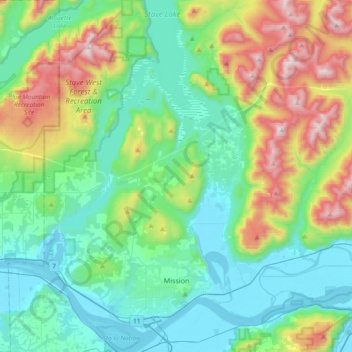
Name: Topografische Karte Mission, Höhe, Relief.
Durchschnittliche Höhe: 345 m
Minimale Höhe: -1 m
Maximale Höhe: 1.329 m
Spenden
Rüste dich für dein nächstes Abenteuer:
Als Amazon-Partner verdient diese Website an qualifizierten Käufen, ohne zusätzliche Kosten für Sie.
Andere topografische Karten
Klicken Sie auf eine Karte, um ihre Topografie, ihre Höhe und ihr Relief anzuzeigen.
Cultus Lake
Canada > British Columbia > Fraser Valley Regional District > Area H (Cultus Lake/Columbia Valley) > Cultus Lake
Durchschnittliche Höhe: 191 m
Harrison River
Canada > British Columbia > Fraser Valley Regional District > Kent > Harrison Mills
Durchschnittliche Höhe: 45 m
Sumas River
Canada > British Columbia > Fraser Valley Regional District > Abbotsford
Durchschnittliche Höhe: 167 m
Agassiz
Canada > British Columbia > Fraser Valley Regional District > Kent
Durchschnittliche Höhe: 48 m
Spenden
Rüste dich für dein nächstes Abenteuer:
Als Amazon-Partner verdient diese Website an qualifizierten Käufen, ohne zusätzliche Kosten für Sie.
Pattinson Peak
Canada > British Columbia > Fraser Valley Regional District > Area F (McConnell Creek/Hatzic Prairie)
Durchschnittliche Höhe: 762 m
Chehalis Lake
Canada > British Columbia > Fraser Valley Regional District > Area C (Sasquatch Country)
Durchschnittliche Höhe: 735 m
Sloquet Creek
Canada > British Columbia > Fraser Valley Regional District > Area C (Sasquatch Country)
Durchschnittliche Höhe: 255 m
Spenden
Rüste dich für dein nächstes Abenteuer:
Als Amazon-Partner verdient diese Website an qualifizierten Käufen, ohne zusätzliche Kosten für Sie.
Campbell Lake
Canada > British Columbia > Fraser Valley Regional District > Kent
Durchschnittliche Höhe: 528 m
Minto Landing
Canada > British Columbia > Fraser Valley Regional District > Chilliwack
Durchschnittliche Höhe: 19 m
Whippoorwill Point
Canada > British Columbia > Fraser Valley Regional District > Harrison Hot Springs
Durchschnittliche Höhe: 115 m
Spenden
Rüste dich für dein nächstes Abenteuer:
Als Amazon-Partner verdient diese Website an qualifizierten Käufen, ohne zusätzliche Kosten für Sie.
Mount Barr
Canada > British Columbia > Fraser Valley Regional District > Area D (Popkum/Bridal Falls/Wahleach)
Mount Barr is a mountain in the Skagit Range of the Cascade Mountains of southern British Columbia, Canada, located on the northeast side of Wahleach Lake and just southwest of Hope. It is a ridge highpoint with an elevation of 1,907 m (6,257 ft).
Durchschnittliche Höhe: 1.414 m
Lindell Beach
Canada > British Columbia > Fraser Valley Regional District > Area H (Cultus Lake/Columbia Valley)
Durchschnittliche Höhe: 268 m
Jones Lake
Canada > British Columbia > Fraser Valley Regional District > Area D (Popkum/Bridal Falls/Wahleach)
Durchschnittliche Höhe: 956 m
Spenden
Rüste dich für dein nächstes Abenteuer:
Als Amazon-Partner verdient diese Website an qualifizierten Käufen, ohne zusätzliche Kosten für Sie.
Harrison Mills
Canada > British Columbia > Fraser Valley Regional District > Area C (Sasquatch Country)
Durchschnittliche Höhe: 95 m
Mount Garibaldi
Canada > British Columbia > Fraser Valley Regional District > Area F (McConnell Creek/Hatzic Prairie)
Mount Garibaldi (Squamish: Nch'ḵay̓, pronounced [n̩.ʧʼqɛˀj̰]) is a dormant stratovolcano in the Garibaldi Ranges of the Pacific Ranges in southwestern British Columbia, Canada. It has a maximum elevation of 2,678 metres (8,786 feet) and rises above the surrounding landscape on the east side of the…
Durchschnittliche Höhe: 2.146 m
Hemlock Valley
Canada > British Columbia > Fraser Valley Regional District > Area C (Sasquatch Country)
Durchschnittliche Höhe: 1.106 m
Canyon Alpine
Canada > British Columbia > Fraser Valley Regional District > Area A (Boston Bar/North Bend/Canyon Alpine)
Durchschnittliche Höhe: 471 m
Spenden
Rüste dich für dein nächstes Abenteuer:
Als Amazon-Partner verdient diese Website an qualifizierten Käufen, ohne zusätzliche Kosten für Sie.
Sunshine Valley
Canada > British Columbia > Fraser Valley Regional District > Area B (South Fraser Canyon/Sunshine Valley)
Durchschnittliche Höhe: 1.030 m
Spuzzum
Canada > British Columbia > Fraser Valley Regional District > Area B (South Fraser Canyon/Sunshine Valley)
In 1956–57, contracts were awarded for the replacement of Spuzzum Creek bridge and associated roadwork, lying west of and higher than the railway bridge. In 1957–58, this work was completed. Once the new Alexandra Bridge opened in 1962, the highway bypassed Spuzzum at a higher elevation and the second…
Durchschnittliche Höhe: 451 m
Abbotsford
Canada > British Columbia > Fraser Valley Regional District > Abbotsford
Durchschnittliche Höhe: 115 m
Lindell Beach
Canada > British Columbia > Fraser Valley Regional District > Area H (Cultus Lake/Columbia Valley)
Durchschnittliche Höhe: 191 m
Spenden
Rüste dich für dein nächstes Abenteuer:
Als Amazon-Partner verdient diese Website an qualifizierten Käufen, ohne zusätzliche Kosten für Sie.
Cheam Peak
Canada > British Columbia > Fraser Valley Regional District > Area E (Chilliwack River Valley)
Durchschnittliche Höhe: 1.471 m
Rosedale
Canada > British Columbia > Fraser Valley Regional District > Chilliwack
Durchschnittliche Höhe: 23 m
Hope
Canada > British Columbia > Fraser Valley Regional District > Hope > Hope
Durchschnittliche Höhe: 435 m
Popkum
Canada > British Columbia > Fraser Valley Regional District > Area D (Popkum/Bridal Falls/Wahleach)
Durchschnittliche Höhe: 101 m
Spenden
Rüste dich für dein nächstes Abenteuer:
Als Amazon-Partner verdient diese Website an qualifizierten Käufen, ohne zusätzliche Kosten für Sie.
Ibex Peak
Canada > British Columbia > Fraser Valley Regional District > Area B (South Fraser Canyon/Sunshine Valley)
Durchschnittliche Höhe: 1.550 m
Deroche
Canada > British Columbia > Fraser Valley Regional District > Area G (Deroche/Dewdney/Sumas Mountain)
Durchschnittliche Höhe: 115 m
Isabel Lake
Canada > British Columbia > Fraser Valley Regional District > Area F (McConnell Creek/Hatzic Prairie)
Durchschnittliche Höhe: 687 m
Vedder River
Canada > British Columbia > Fraser Valley Regional District > Chilliwack
Durchschnittliche Höhe: 110 m
Spenden
Rüste dich für dein nächstes Abenteuer:
Als Amazon-Partner verdient diese Website an qualifizierten Käufen, ohne zusätzliche Kosten für Sie.
Vedder Mountain
Canada > British Columbia > Fraser Valley Regional District > Chilliwack
Durchschnittliche Höhe: 556 m
Yale
Canada > British Columbia > Fraser Valley Regional District > Area B (South Fraser Canyon/Sunshine Valley)
Durchschnittliche Höhe: 340 m
Chehalis River
Canada > British Columbia > Fraser Valley Regional District > Area C (Sasquatch Country)
Durchschnittliche Höhe: 424 m
Keefers
Canada > British Columbia > Fraser Valley Regional District > Area A (Boston Bar/North Bend/Canyon Alpine)
Durchschnittliche Höhe: 400 m
Spenden
Rüste dich für dein nächstes Abenteuer:
Als Amazon-Partner verdient diese Website an qualifizierten Käufen, ohne zusätzliche Kosten für Sie.
Silver Peak
Canada > British Columbia > Fraser Valley Regional District > Area B (South Fraser Canyon/Sunshine Valley)
Durchschnittliche Höhe: 1.354 m
Misty Icefield
Canada > British Columbia > Fraser Valley Regional District > Area F (McConnell Creek/Hatzic Prairie)
Durchschnittliche Höhe: 1.800 m
Hope Slide
Canada > British Columbia > Fraser Valley Regional District > Area B (South Fraser Canyon/Sunshine Valley)
Durchschnittliche Höhe: 1.160 m
Eagle Mountain
Canada > British Columbia > Fraser Valley Regional District > Abbotsford
Durchschnittliche Höhe: 128 m
Spenden
Rüste dich für dein nächstes Abenteuer:
Als Amazon-Partner verdient diese Website an qualifizierten Käufen, ohne zusätzliche Kosten für Sie.
Durieu
Canada > British Columbia > Fraser Valley Regional District > Area F (McConnell Creek/Hatzic Prairie)
Durchschnittliche Höhe: 142 m
Airplane Basin Falls
Canada > British Columbia > Fraser Valley Regional District > Area E (Chilliwack River Valley)
Durchschnittliche Höhe: 1.487 m
Steelhead
Canada > British Columbia > Fraser Valley Regional District > Mission
Durchschnittliche Höhe: 293 m
Spenden
Rüste dich für dein nächstes Abenteuer:
Als Amazon-Partner verdient diese Website an qualifizierten Käufen, ohne zusätzliche Kosten für Sie.
Mount Fletcher
Canada > British Columbia > Fraser Valley Regional District > Area C (Sasquatch Country)
Durchschnittliche Höhe: 953 m
Elk Mountain
Canada > British Columbia > Fraser Valley Regional District > Chilliwack
Durchschnittliche Höhe: 1.009 m
Serpentine Lake
Canada > British Columbia > Fraser Valley Regional District > Area B (South Fraser Canyon/Sunshine Valley)
Durchschnittliche Höhe: 960 m
Agassiz
Canada > British Columbia > Fraser Valley Regional District > Kent
Durchschnittliche Höhe: 48 m
Spenden
Rüste dich für dein nächstes Abenteuer:
Als Amazon-Partner verdient diese Website an qualifizierten Käufen, ohne zusätzliche Kosten für Sie.
Bridal Veil Falls
Canada > British Columbia > Fraser Valley Regional District > Area D (Popkum/Bridal Falls/Wahleach) > Bridal Falls
Durchschnittliche Höhe: 426 m
Stave Falls
Canada > British Columbia > Fraser Valley Regional District > Mission
Durchschnittliche Höhe: 195 m
Airplane Basin Falls
Canada > British Columbia > Fraser Valley Regional District > Area E (Chilliwack River Valley)
Durchschnittliche Höhe: 1.487 m
Teapot Hill
Canada > British Columbia > Fraser Valley Regional District > Area H (Cultus Lake/Columbia Valley)
Durchschnittliche Höhe: 283 m
Spenden
Rüste dich für dein nächstes Abenteuer:
Als Amazon-Partner verdient diese Website an qualifizierten Käufen, ohne zusätzliche Kosten für Sie.
Turner Glacier
Canada > British Columbia > Fraser Valley Regional District > Area C (Sasquatch Country)
Durchschnittliche Höhe: 2.183 m
Mount Garibaldi
Canada > British Columbia > Fraser Valley Regional District > Area F (McConnell Creek/Hatzic Prairie)
Mount Garibaldi (Squamish: Nch'ḵay̓, pronounced [n̩.ʧʼqɛˀj̰]) is a dormant stratovolcano in the Garibaldi Ranges of the Pacific Ranges in southwestern British Columbia, Canada. It has a maximum elevation of 2,678 metres (8,786 feet) and rises above the surrounding landscape on the east side of the…
Durchschnittliche Höhe: 2.146 m
Tamihi Rapids
Canada > British Columbia > Fraser Valley Regional District > Area E (Chilliwack River Valley)
Durchschnittliche Höhe: 252 m
Ryder Lake
Canada > British Columbia > Fraser Valley Regional District > Chilliwack
Durchschnittliche Höhe: 255 m
Spenden
Rüste dich für dein nächstes Abenteuer:
Als Amazon-Partner verdient diese Website an qualifizierten Käufen, ohne zusätzliche Kosten für Sie.
Mount Garibaldi
Canada > British Columbia > Fraser Valley Regional District > Area F (McConnell Creek/Hatzic Prairie)
Mount Garibaldi (Squamish: Nch'ḵay̓, pronounced [n̩.ʧʼqɛˀj̰]) is a dormant stratovolcano in the Garibaldi Ranges of the Pacific Ranges in southwestern British Columbia, Canada. It has a maximum elevation of 2,678 metres (8,786 feet) and rises above the surrounding landscape on the east side of the…
Durchschnittliche Höhe: 2.146 m
Red Mountain
Canada > British Columbia > Fraser Valley Regional District > Mission
Durchschnittliche Höhe: 343 m
Misty Icefield
Canada > British Columbia > Fraser Valley Regional District > Area F (McConnell Creek/Hatzic Prairie)
Durchschnittliche Höhe: 1.800 m
Mount Mercer
Canada > British Columbia > Fraser Valley Regional District > Area E (Chilliwack River Valley)
Durchschnittliche Höhe: 1.359 m
Spenden
Rüste dich für dein nächstes Abenteuer:
Als Amazon-Partner verdient diese Website an qualifizierten Käufen, ohne zusätzliche Kosten für Sie.
Mount Fletcher
Canada > British Columbia > Fraser Valley Regional District > Area C (Sasquatch Country)
Durchschnittliche Höhe: 953 m