
Topografische Karte Weeksville
Interaktive Karte
Klicken Sie auf die Karte, um die Höhe anzuzeigen.
Über diese Karte
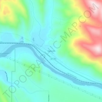
Name: Topografische Karte Weeksville, Höhe, Relief.
Ort: Weeksville, Sanders County, Montana, United States (47.50222 -115.00703 47.54222 -114.96703)
Durchschnittliche Höhe: 864 m
Minimale Höhe: 731 m
Maximale Höhe: 1.237 m
Andere topografische Karten
Klicken Sie auf eine Karte, um ihre Topografie, ihre Höhe und ihr Relief anzuzeigen.
Heron
United States > Montana > Sanders County
Heron, Sanders County, Montana, United States
Durchschnittliche Höhe: 762 m
Paradise
United States > Montana > Sanders County
Paradise, Sanders County, Montana, United States
Durchschnittliche Höhe: 881 m
Thompson Falls
United States > Montana > Sanders County
Thompson Falls, Sanders County, Montana, 59873, United States
Durchschnittliche Höhe: 782 m
Plains
United States > Montana > Sanders County > Plains
Plains, Sanders County, Montana, United States
Durchschnittliche Höhe: 775 m
Thompson Falls
United States > Montana > Sanders County > Thompson Falls
Thompson Falls, Sanders County, Montana, 59873, United States
Durchschnittliche Höhe: 897 m