
Topografische Karte Dhandhuka
Interaktive Karte
Klicken Sie auf die Karte, um die Höhe anzuzeigen.
Dhandhuka
Dhandhuka is located at 22°22′N 71°59′E / 22.37°N 71.98°E / 22.37; 71.98. It has an average elevation of 24 metres (78 feet). The city is 105 km from District center Ahmedabad, on state highway No 1. to Bhavnagar. Bhavnagar is 95 km from Dhandhuka town.
Über diese Karte
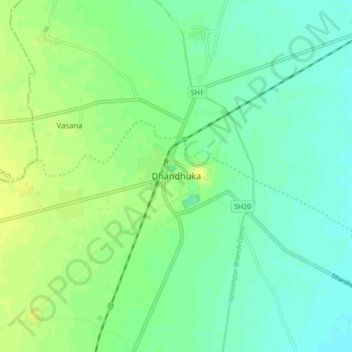
Name: Topografische Karte Dhandhuka, Höhe, Relief.
Durchschnittliche Höhe: 21 m
Minimale Höhe: 13 m
Maximale Höhe: 30 m