
Spenden
Rüste dich für dein nächstes Abenteuer:
Als Amazon-Partner verdient diese Website an qualifizierten Käufen, ohne zusätzliche Kosten für Sie.
Topografische Karte Les Croix
Klicken Sie auf die Karte, um die Höhe anzuzeigen.
Spenden
Rüste dich für dein nächstes Abenteuer:
Als Amazon-Partner verdient diese Website an qualifizierten Käufen, ohne zusätzliche Kosten für Sie.
Über diese Karte
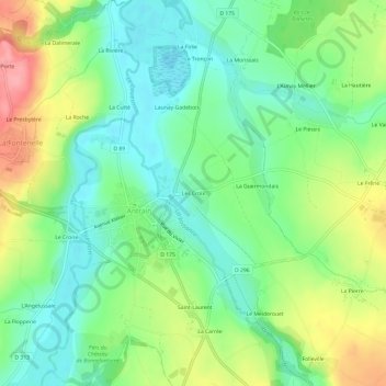
Name: Topografische Karte Les Croix, Höhe, Relief.
Durchschnittliche Höhe: 41 m
Minimale Höhe: 3 m
Maximale Höhe: 106 m
Spenden
Rüste dich für dein nächstes Abenteuer:
Als Amazon-Partner verdient diese Website an qualifizierten Käufen, ohne zusätzliche Kosten für Sie.
Andere topografische Karten
Klicken Sie auf eine Karte, um ihre Topografie, ihre Höhe und ihr Relief anzuzeigen.
Antrain
France > Bretagne > Ille-et-Vilaine > Val-Couesnon
La ville est bâtie sur un petit promontoire de 45 mètres d’altitude situé au confluent de deux cours d’eau : la Loysance et le Couesnon. Elle domine une verte région bocagère. C'est une ville-marché aux petites rues en pente conservant des demeures des XVI et XVII siècles.
Durchschnittliche Höhe: 50 m
Spenden
Rüste dich für dein nächstes Abenteuer:
Als Amazon-Partner verdient diese Website an qualifizierten Käufen, ohne zusätzliche Kosten für Sie.