
Topografische Karte Bwindi Impenetrable National Park
Interaktive Karte
Klicken Sie auf die Karte, um die Höhe anzuzeigen.
Bwindi Impenetrable National Park
Species diversity is a feature of the park. It provides habitat for 120 species of mammals, 348 species of birds, 220 species of butterflies, 27 species of frogs, chameleons, geckos, and many endangered species. Floristically, the park is among the most diverse forests in East Africa, with more than 1,000 flowering plant species, including 163 species of trees and 104 species of ferns. The northern (low elevation) sector has many species of Guineo-Congolian flora, including two endangered species, the brown mahogany and Brazzeia longipedicellata. In particular, the area shares in the high levels of endemisms of the Albertine Rift.
Über diese Karte
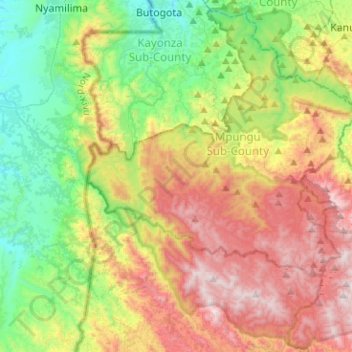
Name: Topografische Karte Bwindi Impenetrable National Park, Höhe, Relief.
Durchschnittliche Höhe: 1.643 m
Minimale Höhe: 1.094 m
Maximale Höhe: 2.446 m
Andere topografische Karten
Klicken Sie auf eine Karte, um ihre Topografie, ihre Höhe und ihr Relief anzuzeigen.
Kisoro
Kisoro is approximately 76 kilometres (47 mi), by road, west of Kabale, the largest city in the Kigezi sub-region. This is approximately 484 kilometres (301 mi), by road, southwest of Kampala, the capital of Uganda and the country's largest city. Kisoro is east of Rumangabo and the Virunga Mountains in the…
Durchschnittliche Höhe: 1.911 m