
Topografische Karte Peace River
Interaktive Karte
Klicken Sie auf die Karte, um die Höhe anzuzeigen.
Peace River
Physiographically, the Town of Peace River lies within the Peace River Formation, a stratigraphical unit of middle Albian age in the Western Canadian Sedimentary Basin. The area developed on sediments of the former lake bottom of Glacial Lake Peace, which covered most of the areas in the region that were below 610 m in elevation.
Über diese Karte
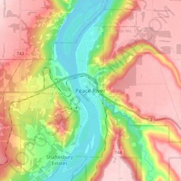
Name: Topografische Karte Peace River, Höhe, Relief.
Ort: Peace River, Alberta, T8S 1P7, Canada (56.19371 -117.33108 56.27371 -117.25108)
Durchschnittliche Höhe: 433 m
Minimale Höhe: 308 m
Maximale Höhe: 551 m