
Topografische Karte Ashby Parva
Interaktive Karte
Klicken Sie auf die Karte, um die Höhe anzuzeigen.
Über diese Karte
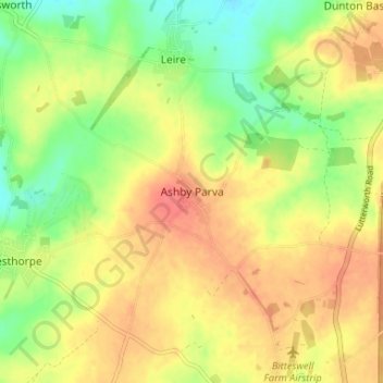
Name: Topografische Karte Ashby Parva, Höhe, Relief.
Durchschnittliche Höhe: 123 m
Minimale Höhe: 93 m
Maximale Höhe: 148 m
Andere topografische Karten
Klicken Sie auf eine Karte, um ihre Topografie, ihre Höhe und ihr Relief anzuzeigen.
Lubenham
United Kingdom > England > Leicestershire > Harborough District
Lubenham, Harborough District, Leicestershire, England, LE16 9TN, United Kingdom
Durchschnittliche Höhe: 105 m
Cranoe
United Kingdom > England > Leicestershire > Harborough District
Cranoe, Harborough District, Leicestershire, England, LE16 7SW, United Kingdom
Durchschnittliche Höhe: 108 m
Great Easton
United Kingdom > England > Leicestershire > Harborough District > Great Easton
Great Easton, Harborough District, Leicestershire, England, LE16 8SL, United Kingdom
Durchschnittliche Höhe: 72 m
Catthorpe
United Kingdom > England > Leicestershire > Harborough District > Catthorpe
Catthorpe, Harborough District, Leicestershire, England, LE17 6DD, United Kingdom
Durchschnittliche Höhe: 113 m
Church Langton
United Kingdom > England > Leicestershire > Harborough District > Church Langton
Church Langton, Harborough District, Leicestershire, England, LE16 7FW, United Kingdom
Durchschnittliche Höhe: 100 m
Upper Bruntingthorpe
United Kingdom > England > Leicestershire > Harborough District > Walton > Upper Bruntingthorpe
Upper Bruntingthorpe, Bruntingthorpe, Walton, Harborough District, Leicestershire, England, LE17 5QP, United Kingdom
Durchschnittliche Höhe: 143 m
Carlton Carlieu
United Kingdom > England > Leicestershire > Harborough District > Carlton Carlieu
Carlton Carlieu, Harborough District, Leicestershire, England, United Kingdom
Durchschnittliche Höhe: 135 m
Eyebrook Reservoir
United Kingdom > England > Leicestershire > Harborough District > Stockerston
Eyebrook Reservoir, Stockerston, Harborough District, Leicestershire, East Midlands, England, United Kingdom
Durchschnittliche Höhe: 85 m
Ingarsby
United Kingdom > England > Leicestershire > Harborough District > Ingarsby
Ingarsby, Hungarton, Harborough District, Leicestershire, East Midlands, England, LE7 9JL, United Kingdom
Durchschnittliche Höhe: 139 m
Blaston
United Kingdom > England > Leicestershire > Harborough District
Blaston, Harborough District, Leicestershire, England, LE16 8DE, United Kingdom
Durchschnittliche Höhe: 112 m
North Kilworth
United Kingdom > England > Leicestershire > Harborough District
North Kilworth, Harborough District, Leicestershire, England, LE17 6HQ, United Kingdom
Durchschnittliche Höhe: 142 m
Dunton Bassett
United Kingdom > England > Leicestershire > Harborough District
Dunton Bassett, Harborough District, Leicestershire, England, LE17 5LL, United Kingdom
Durchschnittliche Höhe: 117 m
Cotesbach
United Kingdom > England > Leicestershire > Harborough District
Cotesbach, Harborough District, Leicestershire, England, LE17 4HZ, United Kingdom
Durchschnittliche Höhe: 122 m
Allexton
United Kingdom > England > Leicestershire > Harborough District
Allexton, Harborough District, Leicestershire, England, LE15 9AG, United Kingdom
Durchschnittliche Höhe: 128 m
Gilmorton
United Kingdom > England > Leicestershire > Harborough District
Gilmorton, Harborough District, Leicestershire, England, LE17 5PA, United Kingdom
Durchschnittliche Höhe: 138 m
Smeeton Westerby
United Kingdom > England > Leicestershire > Harborough District
Smeeton Westerby, Harborough District, Leicestershire, England, LE8 0RT, United Kingdom
Durchschnittliche Höhe: 114 m