
Spenden
Rüste dich für dein nächstes Abenteuer:
Als Amazon-Partner verdient diese Website an qualifizierten Käufen, ohne zusätzliche Kosten für Sie.
Topografische Karte Wigginton
Klicken Sie auf die Karte, um die Höhe anzuzeigen.
Spenden
Rüste dich für dein nächstes Abenteuer:
Als Amazon-Partner verdient diese Website an qualifizierten Käufen, ohne zusätzliche Kosten für Sie.
Über diese Karte
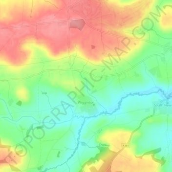
Name: Topografische Karte Wigginton, Höhe, Relief.
Durchschnittliche Höhe: 154 m
Minimale Höhe: 109 m
Maximale Höhe: 203 m
Spenden
Rüste dich für dein nächstes Abenteuer:
Als Amazon-Partner verdient diese Website an qualifizierten Käufen, ohne zusätzliche Kosten für Sie.
Andere topografische Karten
Klicken Sie auf eine Karte, um ihre Topografie, ihre Höhe und ihr Relief anzuzeigen.
Great Bourton
United Kingdom > England > Oxfordshire > Cherwell District
Durchschnittliche Höhe: 118 m
Roman Meadow Banbury Country Park
United Kingdom > England > Oxfordshire > Cherwell District > Little Bourton
Durchschnittliche Höhe: 103 m
Stoke Lyne
United Kingdom > England > Oxfordshire > Cherwell District > Stoke Lyne
Durchschnittliche Höhe: 116 m
Spenden
Rüste dich für dein nächstes Abenteuer:
Als Amazon-Partner verdient diese Website an qualifizierten Käufen, ohne zusätzliche Kosten für Sie.
Shipton-on-Cherwell
United Kingdom > England > Oxfordshire > Cherwell District
Durchschnittliche Höhe: 78 m
Spenden
Rüste dich für dein nächstes Abenteuer:
Als Amazon-Partner verdient diese Website an qualifizierten Käufen, ohne zusätzliche Kosten für Sie.
Christmas Corner
United Kingdom > England > Oxfordshire > Cherwell District
Durchschnittliche Höhe: 168 m
Hampton Gay
United Kingdom > England > Oxfordshire > Cherwell District > Shipton-on-Cherwell
Durchschnittliche Höhe: 75 m
Little Chesterton
United Kingdom > England > Oxfordshire > Cherwell District > Wendlebury
Durchschnittliche Höhe: 72 m
Spenden
Rüste dich für dein nächstes Abenteuer:
Als Amazon-Partner verdient diese Website an qualifizierten Käufen, ohne zusätzliche Kosten für Sie.
Williamscot
United Kingdom > England > Oxfordshire > Cherwell District > Cropredy > Williamscot
Durchschnittliche Höhe: 118 m
Down End
United Kingdom > England > Oxfordshire > Cherwell District > Hook Norton
Durchschnittliche Höhe: 173 m
Spenden
Rüste dich für dein nächstes Abenteuer:
Als Amazon-Partner verdient diese Website an qualifizierten Käufen, ohne zusätzliche Kosten für Sie.
Nethercote
United Kingdom > England > Oxfordshire > Cherwell District > Banbury
Durchschnittliche Höhe: 111 m
Nethercote
United Kingdom > England > Oxfordshire > Cherwell District > Banbury
Durchschnittliche Höhe: 111 m
Spenden
Rüste dich für dein nächstes Abenteuer:
Als Amazon-Partner verdient diese Website an qualifizierten Käufen, ohne zusätzliche Kosten für Sie.
Great Bourton
United Kingdom > England > Oxfordshire > Cherwell District
Durchschnittliche Höhe: 118 m