
Spenden
Rüste dich für dein nächstes Abenteuer:
Als Amazon-Partner verdient diese Website an qualifizierten Käufen, ohne zusätzliche Kosten für Sie.
Topografische Karte Hoffman Notch Wilderness
Klicken Sie auf die Karte, um die Höhe anzuzeigen.
Spenden
Rüste dich für dein nächstes Abenteuer:
Als Amazon-Partner verdient diese Website an qualifizierten Käufen, ohne zusätzliche Kosten für Sie.
Hoffman Notch Wilderness
The forest cover ranges from second growth hardwoods of sapling and pole-size to nearly solid conifer stands of near mature size at the higher elevations. On some of the better soil, exceptionally large diameter hardwoods occur.
Spenden
Rüste dich für dein nächstes Abenteuer:
Als Amazon-Partner verdient diese Website an qualifizierten Käufen, ohne zusätzliche Kosten für Sie.
Über diese Karte
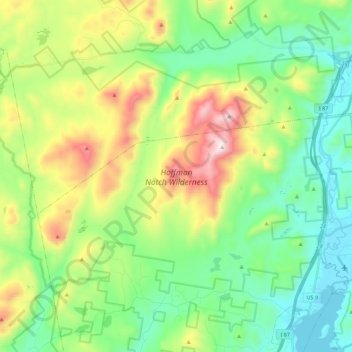
Name: Topografische Karte Hoffman Notch Wilderness, Höhe, Relief.
Durchschnittliche Höhe: 515 m
Minimale Höhe: 242 m
Maximale Höhe: 1.108 m
Spenden
Rüste dich für dein nächstes Abenteuer:
Als Amazon-Partner verdient diese Website an qualifizierten Käufen, ohne zusätzliche Kosten für Sie.