
Spenden
Rüste dich für dein nächstes Abenteuer:
Als Amazon-Partner verdient diese Website an qualifizierten Käufen, ohne zusätzliche Kosten für Sie.
Topografische Karte Riverhead
Klicken Sie auf die Karte, um die Höhe anzuzeigen.
Spenden
Rüste dich für dein nächstes Abenteuer:
Als Amazon-Partner verdient diese Website an qualifizierten Käufen, ohne zusätzliche Kosten für Sie.
Über diese Karte
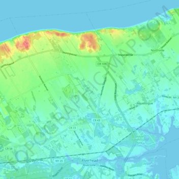
Name: Topografische Karte Riverhead, Höhe, Relief.
Durchschnittliche Höhe: 13 m
Minimale Höhe: -13 m
Maximale Höhe: 69 m
Spenden
Rüste dich für dein nächstes Abenteuer:
Als Amazon-Partner verdient diese Website an qualifizierten Käufen, ohne zusätzliche Kosten für Sie.
Andere topografische Karten
Klicken Sie auf eine Karte, um ihre Topografie, ihre Höhe und ihr Relief anzuzeigen.
Smithtown Pines
United States > New York > Suffolk County > Town of Smithtown
Durchschnittliche Höhe: 29 m
Bald Hill
United States > New York > Suffolk County > Town of Southampton
Durchschnittliche Höhe: 47 m
South Setauket
United States > New York > Suffolk County > Town of Brookhaven
Durchschnittliche Höhe: 44 m
Spenden
Rüste dich für dein nächstes Abenteuer:
Als Amazon-Partner verdient diese Website an qualifizierten Käufen, ohne zusätzliche Kosten für Sie.
Jericho
United States > New York > Suffolk County > Village of East Hampton
Durchschnittliche Höhe: 9 m
Jayne's Hill
United States > New York > Suffolk County > Town of Huntington
Jayne's Hill (also known as High Hill, West Hills, Oakley's Hill, and Janes Hill) is the highest point on Long Island, New York, with an elevation of between 387 feet (118 m) and 400.9 feet (122.2 m) above sea level. It is situated on the Harbor Hill moraine, a terminal moraine that makes up the northern spine…
Durchschnittliche Höhe: 73 m
Spenden
Rüste dich für dein nächstes Abenteuer:
Als Amazon-Partner verdient diese Website an qualifizierten Käufen, ohne zusätzliche Kosten für Sie.
Apaquogue
United States > New York > Suffolk County > Village of East Hampton
Durchschnittliche Höhe: 5 m
Benjamin's Memorial Beach
United States > New York > Suffolk County > Bay Shore
Durchschnittliche Höhe: 2 m
Spenden
Rüste dich für dein nächstes Abenteuer:
Als Amazon-Partner verdient diese Website an qualifizierten Käufen, ohne zusätzliche Kosten für Sie.
Shinnecock Indian Territory
United States > New York > Suffolk County > Town of Southampton
Durchschnittliche Höhe: 4 m
East Cutchogue
United States > New York > Suffolk County > Town of Southold
Durchschnittliche Höhe: 9 m
Greenport
United States > New York > Suffolk County > Greenport > Greenport
Durchschnittliche Höhe: 4 m
Spenden
Rüste dich für dein nächstes Abenteuer:
Als Amazon-Partner verdient diese Website an qualifizierten Käufen, ohne zusätzliche Kosten für Sie.
Millers Pond
United States > New York > Suffolk County > Town of Smithtown > Village of the Branch
Durchschnittliche Höhe: 20 m
Spenden
Rüste dich für dein nächstes Abenteuer:
Als Amazon-Partner verdient diese Website an qualifizierten Käufen, ohne zusätzliche Kosten für Sie.
East Cutchogue
United States > New York > Suffolk County > Town of Southold
Durchschnittliche Höhe: 9 m
Spenden
Rüste dich für dein nächstes Abenteuer:
Als Amazon-Partner verdient diese Website an qualifizierten Käufen, ohne zusätzliche Kosten für Sie.
Cherry Grove
United States > New York > Suffolk County > Town of Brookhaven
Durchschnittliche Höhe: 0 m
Sunken Meadow
United States > New York > Suffolk County > Town of Smithtown
Durchschnittliche Höhe: 18 m
East Hauppauge
United States > New York > Suffolk County > Town of Smithtown
Durchschnittliche Höhe: 28 m
Spenden
Rüste dich für dein nächstes Abenteuer:
Als Amazon-Partner verdient diese Website an qualifizierten Käufen, ohne zusätzliche Kosten für Sie.
Midhampton
United States > New York > Suffolk County > Town of East Hampton
Durchschnittliche Höhe: 10 m
Jacobs Hill
United States > New York > Suffolk County > Town of Riverhead
Durchschnittliche Höhe: 11 m
Spenden
Rüste dich für dein nächstes Abenteuer:
Als Amazon-Partner verdient diese Website an qualifizierten Käufen, ohne zusätzliche Kosten für Sie.
Eastport South Manor Athletic Complex
United States > New York > Suffolk County > Town of Brookhaven > Eastport
Durchschnittliche Höhe: 15 m
Midhampton
United States > New York > Suffolk County > Town of East Hampton
Durchschnittliche Höhe: 10 m
Benjamin's Memorial Beach
United States > New York > Suffolk County > Bay Shore
Durchschnittliche Höhe: 2 m
Hampton Park
United States > New York > Suffolk County > North Sea > Town of Southampton
Durchschnittliche Höhe: 17 m
Spenden
Rüste dich für dein nächstes Abenteuer:
Als Amazon-Partner verdient diese Website an qualifizierten Käufen, ohne zusätzliche Kosten für Sie.
Water Island
United States > New York > Suffolk County > Town of Brookhaven
Durchschnittliche Höhe: 0 m
Squiretown
United States > New York > Suffolk County > Hampton Bays > Town of Southampton
Durchschnittliche Höhe: 13 m
East Hampton
United States > New York > Suffolk County > East Hampton > Village of East Hampton
Durchschnittliche Höhe: 12 m
Spenden
Rüste dich für dein nächstes Abenteuer:
Als Amazon-Partner verdient diese Website an qualifizierten Käufen, ohne zusätzliche Kosten für Sie.
Centerport
United States > New York > Suffolk County > Huntington > Centerport
Durchschnittliche Höhe: 44 m
Jericho
United States > New York > Suffolk County > Village of East Hampton
Durchschnittliche Höhe: 9 m
Battery Barlow (historical)
United States > New York > Suffolk County > Fishers Island > Fishers Island
Durchschnittliche Höhe: 1 m
Spenden
Rüste dich für dein nächstes Abenteuer:
Als Amazon-Partner verdient diese Website an qualifizierten Käufen, ohne zusätzliche Kosten für Sie.
Montauk Station
United States > New York > Suffolk County > Town of East Hampton > Montauk > Montauk Station
Durchschnittliche Höhe: 11 m
Pine Neck
United States > New York > Suffolk County > East Quogue > Town of Southampton
Durchschnittliche Höhe: 4 m
Spenden
Rüste dich für dein nächstes Abenteuer:
Als Amazon-Partner verdient diese Website an qualifizierten Käufen, ohne zusätzliche Kosten für Sie.