
Topografische Karte Lake McDonald
Interaktive Karte
Klicken Sie auf die Karte, um die Höhe anzuzeigen.
Über diese Karte
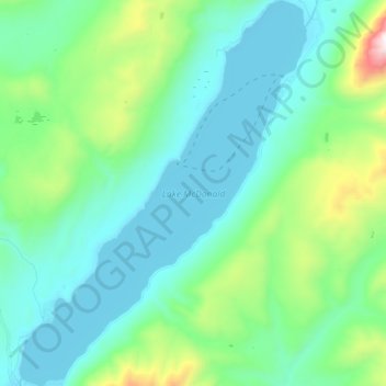
Name: Topografische Karte Lake McDonald, Höhe, Relief.
Ort: Lake McDonald, Flathead County, Montana, United States (48.52745 -113.99626 48.64055 -113.86895)
Durchschnittliche Höhe: 1.209 m
Minimale Höhe: 954 m
Maximale Höhe: 2.265 m
Lake McDonald is the largest lake in Glacier National Park. It is located at 48°35′N 113°55′W / 48.583°N 113.917°W / 48.583; -113.917 in Flathead County in the U.S. state of Montana. Lake McDonald is approximately 10 miles (16 km) long, and over a mile (1.6 km) wide and 472 feet (130 m) deep, filling a valley formed by a combination of erosion and glacial activity. Lake McDonald lies at an elevation of 3,153 feet (961 m) and is on the west side of the Continental Divide. Going-to-the-Sun Road parallels the lake along its southern shoreline. The surface area of the lake is 6,823 acres (27.6 km2).
Andere topografische Karten
Klicken Sie auf eine Karte, um ihre Topografie, ihre Höhe und ihr Relief anzuzeigen.
Glacier National Park
United States > Montana > Flathead County
Glacier National Park, Flathead County, Montana, United States
Durchschnittliche Höhe: 1.594 m
Whitefish
United States > Montana > Flathead County
Whitefish, Flathead County, Montana, United States
Durchschnittliche Höhe: 1.073 m
Marion
United States > Montana > Flathead County
Marion, Flathead County, Montana, United States
Durchschnittliche Höhe: 1.236 m
Kalispell
United States > Montana > Flathead County
Kalispell, Flathead County, Montana, United States
Durchschnittliche Höhe: 934 m
Niarada
United States > Montana > Flathead County
Niarada, Flathead County, Montana, United States
Durchschnittliche Höhe: 1.053 m
Evergreen
United States > Montana > Flathead County
Evergreen, Flathead County, Montana, United States
Durchschnittliche Höhe: 895 m
Condor Peak
United States > Montana > Flathead County
Condor Peak, Flathead County, Montana, United States
Durchschnittliche Höhe: 1.848 m
Columbia Falls
United States > Montana > Flathead County
Columbia Falls, Flathead County, Montana, 59912, United States
Durchschnittliche Höhe: 934 m
Apgar
United States > Montana > Flathead County
Apgar, Flathead County, Montana, 59936, United States
Durchschnittliche Höhe: 1.080 m
Somers
United States > Montana > Flathead County
Somers, Flathead County, Montana, United States
Durchschnittliche Höhe: 915 m
Lakeside
United States > Montana > Flathead County
Lakeside, Flathead County, Montana, 59922, United States
Durchschnittliche Höhe: 1.034 m
Bigfork
United States > Montana > Flathead County
Bigfork, Flathead County, Montana, United States
Durchschnittliche Höhe: 922 m
Bowman Lake
United States > Montana > Flathead County
Bowman Lake, Flathead County, Montana, United States
Durchschnittliche Höhe: 1.639 m
Polebridge
United States > Montana > Flathead County
Polebridge, Flathead County, Montana, 59928, United States
Durchschnittliche Höhe: 1.118 m
Kalispell
United States > Montana > Flathead County > Kalispell
Kalispell, Flathead County, Montana, 59901-4451, United States
Durchschnittliche Höhe: 1.055 m
Canyon Point
United States > Montana > Flathead County
Canyon Point, Flathead County, Montana, United States
Durchschnittliche Höhe: 1.750 m
Graves Creek
United States > Montana > Flathead County
Graves Creek, Flathead County, Montana, United States
Durchschnittliche Höhe: 1.694 m
Kila
United States > Montana > Flathead County
Kila, Flathead County, Montana, 59920, United States
Durchschnittliche Höhe: 1.013 m
Lake Ellen Wilson
United States > Montana > Flathead County
Lake Ellen Wilson, Flathead County, Montana, United States
Durchschnittliche Höhe: 2.100 m
West Glacier
United States > Montana > Flathead County
West Glacier, Flathead County, Montana, 59936, United States
Durchschnittliche Höhe: 1.201 m
Coal Creek
United States > Montana > Flathead County
Coal Creek, Flathead County, Montana, United States
Durchschnittliche Höhe: 1.287 m
Cone Peak
United States > Montana > Flathead County
Cone Peak, Flathead County, Montana, United States
Durchschnittliche Höhe: 1.819 m
Heavens Peak
United States > Montana > Flathead County
Heavens Peak, Flathead County, Montana, United States
Durchschnittliche Höhe: 2.055 m