
Spenden
Rüste dich für dein nächstes Abenteuer:
Als Amazon-Partner verdient diese Website an qualifizierten Käufen, ohne zusätzliche Kosten für Sie.
Topografische Karte Avenal
Klicken Sie auf die Karte, um die Höhe anzuzeigen.
Spenden
Rüste dich für dein nächstes Abenteuer:
Als Amazon-Partner verdient diese Website an qualifizierten Käufen, ohne zusätzliche Kosten für Sie.
Avenal
Avenal (Spanish for "Oat field") is a city in Kings County, California, United States. Avenal is located 35 miles (56 km) southwest of Hanford, at an elevation of 807 ft (246 m). It is part of the Hanford–Corcoran Metropolitan Statistical Area (MSA Code 25260), which encompasses all of Kings County. In area, it is the fourth-largest city in Kings County. The ZIP Code for this community is 93204, and telephone numbers use the sequence (559) 386-XXXX. The population was 15,505 in the 2010 census, which includes inmates at the Avenal State Prison, the first prison actively solicited by a community in the state of California. Many of the remaining residents largely either work at the prison or in the agriculture industry. The prison provides approximately 1,000 jobs to residents. The California Department of Finance estimated that Avenal's population was 13,496 on July 1, 2019. As of that date, Avenal State Prison held 4,165 inmates, which was about 32% of the total population of Avenal. Inmates are counted as city residents by both the United States census and the California Department of Finance.
Spenden
Rüste dich für dein nächstes Abenteuer:
Als Amazon-Partner verdient diese Website an qualifizierten Käufen, ohne zusätzliche Kosten für Sie.
Über diese Karte
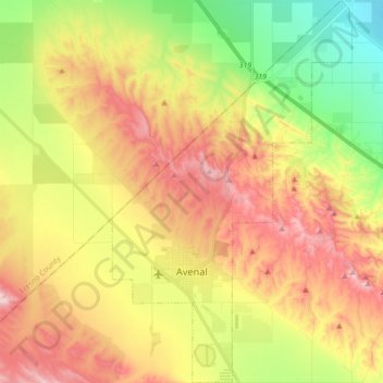
Name: Topografische Karte Avenal, Höhe, Relief.
Ort: Avenal, Kings County, California, United States (35.96393 -120.16483 36.10227 -120.05731)
Durchschnittliche Höhe: 247 m
Minimale Höhe: 87 m
Maximale Höhe: 415 m
Spenden
Rüste dich für dein nächstes Abenteuer:
Als Amazon-Partner verdient diese Website an qualifizierten Käufen, ohne zusätzliche Kosten für Sie.
Andere topografische Karten
Klicken Sie auf eine Karte, um ihre Topografie, ihre Höhe und ihr Relief anzuzeigen.
Stratford
United States > California > Kings County
Stratford (formerly, Stratton) is a census-designated place (CDP) in Kings County, California, United States. Stratford is located 14 miles (23 km) southwest of Hanford, at an elevation of 203 feet (62 m). It is part of the Hanford–Lemoore Metropolitan Statistical Area. The population was 1,277 at the 2010…
Durchschnittliche Höhe: 59 m
Kettleman City
United States > California > Kings County
Kettleman City is a census-designated place (CDP) in Kings County, California, United States. Kettleman City is located 28 miles (45 km) southwest of Hanford, 54 miles (88 km) south of Fresno, at an elevation of 253 feet (77 m), and sits only about 1/2 mile north of the 36th parallel north latitude. It is part…
Durchschnittliche Höhe: 88 m
Kettleman City
United States > California > Kings County
Kettleman City is a census-designated place (CDP) in Kings County, California, United States. Kettleman City is located 28 miles (45 km) southwest of Hanford, 54 miles (88 km) south of Fresno, at an elevation of 253 feet (77 m), and sits only about 1/2 mile north of the 36th parallel north latitude. It is part…
Durchschnittliche Höhe: 84 m
Spenden
Rüste dich für dein nächstes Abenteuer:
Als Amazon-Partner verdient diese Website an qualifizierten Käufen, ohne zusätzliche Kosten für Sie.