Geolokalisieren
👉 Easily get elevation data in JSON, GeoTIFF and KML formats using Elevation API
Vielen Dank für die Unterstützung dieser Website ❤️
Spenden

Rüste dich für dein nächstes Abenteuer:

Als Amazon-Partner verdient diese Website an qualifizierten Käufen, ohne zusätzliche Kosten für Sie.

Topografische Karte Panchkula

Klicken Sie auf die Karte, um die Höhe anzuzeigen.

Über diese Karte

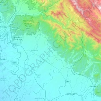
Name: Topografische Karte Panchkula, Höhe, Relief.

Ort: Panchkula, Panchkula District, Haryana, India (30.64050 76.82504 30.78711 76.91545)

Durchschnittliche Höhe: 388 m

Minimale Höhe: 300 m

Maximale Höhe: 725 m

👉 Easily get elevation data in JSON, GeoTIFF and KML formats using Elevation API
Vielen Dank für die Unterstützung dieser Website ❤️
Spenden

Andere topografische Karten

Klicken Sie auf eine Karte, um ihre Topografie, ihre Höhe und ihr Relief anzuzeigen.

Karnal

India > Haryana > Karnal

Durchschnittliche Höhe: 247 m

Sahu

India > Haryana > Uklana ST

Durchschnittliche Höhe: 220 m

Morni

India > Haryana > Morni

Durchschnittliche Höhe: 918 m

Kalwan

India > Haryana > Ujhana

Durchschnittliche Höhe: 227 m

Hudina

India > Haryana > Narnaul

Durchschnittliche Höhe: 291 m

Shahbad

India > Haryana > Shahbad

Durchschnittliche Höhe: 265 m

Hodal

India > Haryana > Hodal

Hodal is a town and a municipal council, located, on Palwal Road in Palwal district in the Haryana state of India.It is Part of Braj region. Its language is Braj bhasha & Haryanvi. It is located at 27°53′39″N 77°22′09″E / 27.89417°N 77.36917°E / 27.89417; 77.36917 and has an average…

Durchschnittliche Höhe: 190 m

Payaga

India > Haryana > Mahendragarh

Durchschnittliche Höhe: 272 m

Sultanpur National Park

India > Haryana > Gurugram

Durchschnittliche Höhe: 216 m

Kala Amb

India > Haryana > Naraingarh

Durchschnittliche Höhe: 387 m

Daha

India > Haryana > Karnal

Durchschnittliche Höhe: 246 m

Budha Khera

India > Haryana > Karnal

Durchschnittliche Höhe: 248 m

Vielen Dank für die Unterstützung dieser Website ❤️
Spenden

Tauru

India > Haryana > Taoru

Taoru is located at 28°13′N 76°57′E / 28.22°N 76.95°E / 28.22; 76.95. It has an average elevation of 262 metres (859 feet). It is surrounded by Aravalli Range from three sides.

Durchschnittliche Höhe: 267 m

Hisar

India > Haryana > Hisar

Hisar is located at 29°05′N 75°26′E / 29.09°N 75.43°E / 29.09; 75.43 in western Haryana. It has an average elevation of 215 m (705 ft) above mean sea level. The region is part of the alluvial Ghaggar-Yamuna plain and its southern and western portions mark a gradual transition to the desert.…

Durchschnittliche Höhe: 213 m

Lahrara

India > Haryana > Sonipat

Durchschnittliche Höhe: 222 m

Morni Hills (Khol-Hi-Raitan) WLS

India > Haryana > Barwala > Barwala

Durchschnittliche Höhe: 484 m

SECTOR 79

India > Haryana > Faridabad

Durchschnittliche Höhe: 202 m

Babarpur

India > Haryana > Panipat

Durchschnittliche Höhe: 238 m

Nuh

India > Haryana > Nuh

Durchschnittliche Höhe: 205 m

Kosli

India > Haryana > Kosli

Durchschnittliche Höhe: 231 m

Para River

India > Haryana > Siwan > KACHI PISOL

Durchschnittliche Höhe: 235 m

Murthal

India > Haryana > Sonipat

Durchschnittliche Höhe: 219 m

Uklana Mandi

India > Haryana > Uklana ST

Durchschnittliche Höhe: 221 m

Baghola

India > Haryana > Palwal

Durchschnittliche Höhe: 196 m

Vielen Dank für die Unterstützung dieser Website ❤️
Spenden

Rüste dich für dein nächstes Abenteuer:

Als Amazon-Partner verdient diese Website an qualifizierten Käufen, ohne zusätzliche Kosten für Sie.

Salarpur

India > Haryana > Thanesar

Durchschnittliche Höhe: 254 m

Rahaka

India > Haryana

Durchschnittliche Höhe: 198 m

Barsi

India > Haryana > Bawani Khera

Durchschnittliche Höhe: 218 m

Nasipur

India > Haryana > Karnal

Durchschnittliche Höhe: 247 m

Manethi

India > Haryana > Rewari

Durchschnittliche Höhe: 305 m

Charkhi Dadri

India > Haryana > Dadri

Durchschnittliche Höhe: 218 m

Ralli

India > Haryana > Panchkula > Ralli

Durchschnittliche Höhe: 324 m

Surajkund

India > Haryana > Faridabád

In the Aravalli hill ranges, which spreads over Delhi and Haryana, where the Surajkund and the Anagpur Dam are located, ancient Stone Age relics have been revealed. The Aravallis, which strike out in two directions from Delhi exhibits a topography of low and rugged hills. The stratigraphy in the area is…

Durchschnittliche Höhe: 230 m

Vielen Dank für die Unterstützung dieser Website ❤️
Spenden

Sunderpur

India > Haryana > Sunderpur

Durchschnittliche Höhe: 227 m

SECTOR 78

India > Haryana > Faridabad

Durchschnittliche Höhe: 202 m

Mewala Maharajpur

India > Haryana > Faridabád > Mewala Maharajpur

Durchschnittliche Höhe: 213 m

Pinjore

India > Haryana > Kalka > Pinjore

Durchschnittliche Höhe: 554 m

Wazirabad

India > Haryana > Gurugram

Durchschnittliche Höhe: 241 m

Pundri

India > Haryana > Fatehpur Pundri > Pundri

Durchschnittliche Höhe: 242 m

Dhobi

India > Haryana > Narwana > Dhobi

Durchschnittliche Höhe: 227 m

Dang

India > Haryana > Bawani Khera > Dang

Durchschnittliche Höhe: 215 m

Ambala

India > Haryana > Ambala

Durchschnittliche Höhe: 651 m

Paintawas Khurd

India > Haryana > Dadri > Paintawas Khurd

Durchschnittliche Höhe: 216 m

Narnaul

India > Haryana > Narnaul

Narnaul is located at 28°02′N 76°07′E / 28.04°N 76.11°E / 28.04; 76.11. It has an average elevation of 300 meters (977 feet). The district is rich in mineral resources such as iron ore, copper ore, beryl, tourmaline, muscovite, biotite, albite, calcite, and quartz.

Durchschnittliche Höhe: 318 m

Rohtak

India > Haryana > Rohtak

Durchschnittliche Höhe: 230 m

Vielen Dank für die Unterstützung dieser Website ❤️
Spenden

Rüste dich für dein nächstes Abenteuer:

Als Amazon-Partner verdient diese Website an qualifizierten Käufen, ohne zusätzliche Kosten für Sie.

Bohar

India > Haryana > Rohtak

Durchschnittliche Höhe: 222 m

Kalanaur

India > Haryana > Kalanaur

Durchschnittliche Höhe: 220 m

Rüste dich für dein nächstes Abenteuer:

🧲Peilkompass für Profis - Exaktes Anvisieren von Geländepunkten zur Standortbestimmung
⛑️Erste Hilfe Set Outdoor - Sicherheit für unterwegs
👒Sonnenhut mit Nackenschutz - Maximaler Schutz vor Sonnenbrand im Hochgebirge
🎒Rucksack-Regenschutz - Hält den Inhalt trocken, wenn das Wetter umschlägt
🧭Kompass - Klassische Orientierungshilfe für Kartenarbeit

Als Amazon-Partner verdient diese Website an qualifizierten Käufen, ohne zusätzliche Kosten für Sie.