
Topografische Karte Seguin
Interaktive Karte
Klicken Sie auf die Karte, um die Höhe anzuzeigen.
Über diese Karte
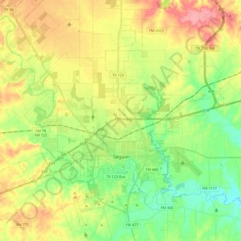
Name: Topografische Karte Seguin, Höhe, Relief.
Ort: Seguin, Guadalupe County, Texas, United States (29.51199 -98.06061 29.68388 -97.83581)
Durchschnittliche Höhe: 172 m
Minimale Höhe: 128 m
Maximale Höhe: 229 m
The elevation at the courthouse is 522 feet (159 m) above mean sea level.
Andere topografische Karten
Klicken Sie auf eine Karte, um ihre Topografie, ihre Höhe und ihr Relief anzuzeigen.
Cibolo
United States > Texas > Guadalupe County
Cibolo, Guadalupe County, Texas, 78108, United States
Durchschnittliche Höhe: 220 m
Schertz
United States > Texas > Guadalupe County
Schertz, Guadalupe County, Texas, 78154, United States
Durchschnittliche Höhe: 232 m
Zorn
United States > Texas > Guadalupe County
Zorn, Guadalupe County, Texas, United States
Durchschnittliche Höhe: 169 m
Kingsbury
United States > Texas > Guadalupe County
Kingsbury, Guadalupe County, Texas, United States
Durchschnittliche Höhe: 166 m