
Topografische Karte West Richland
Interaktive Karte
Klicken Sie auf die Karte, um die Höhe anzuzeigen.
Über diese Karte
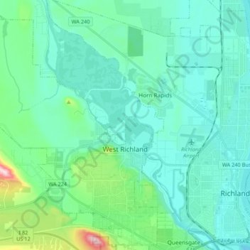
Name: Topografische Karte West Richland, Höhe, Relief.
Durchschnittliche Höhe: 146 m
Minimale Höhe: 93 m
Maximale Höhe: 424 m
The original people of the region were the Chemnapum Indians (closely related to the Wanapum tribe), living near the mouth of the Yakima River. Lewis and Clark passed through the area in 1805, and an expedition of the Army Corps of Topographical Engineers headed by Robert E Johnson mapped the Yakima Valley in 1841.
Andere topografische Karten
Klicken Sie auf eine Karte, um ihre Topografie, ihre Höhe und ihr Relief anzuzeigen.
Richland
United States > Washington > Benton County
Richland, Benton County, Washington, United States
Durchschnittliche Höhe: 160 m
Kennewick
United States > Washington > Benton County
Kennewick, Benton County, Washington, United States
Durchschnittliche Höhe: 154 m
Columbia Plateau
United States > Washington > Benton County
Columbia Plateau, Benton County, Washington, United States
Durchschnittliche Höhe: 221 m