
Topografische Karte Kings Canyon National Park
Interaktive Karte
Klicken Sie auf die Karte, um die Höhe anzuzeigen.
Über diese Karte
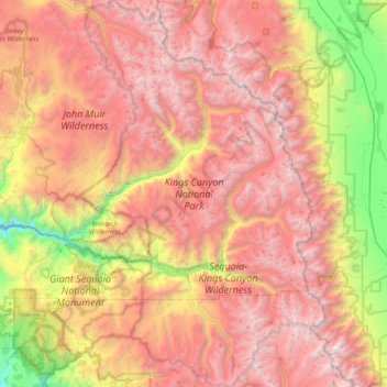
Name: Topografische Karte Kings Canyon National Park, Höhe, Relief.
Durchschnittliche Höhe: 2.591 m
Minimale Höhe: 630 m
Maximale Höhe: 4.372 m
Kings Canyon is characterized by some of the steepest vertical relief in North America, with numerous peaks over 14,000 feet (4,300 m) on the Sierra Crest along the park's eastern border, falling to 4,500 feet (1,400 m) in the valley floor of Cedar Grove just ten miles (16 km) to the west. The Sierran crest forms the eastern boundary of the park, from Mount Goethe in the north, down to Junction Peak, at the boundary with Sequoia National Park. Several passes cross the crest into the park, including Bishop Pass, Taboose Pass, Sawmill Pass, and Kearsarge Pass. All of these passes are above 11,000 feet (3,400 m) in elevation.
Andere topografische Karten
Klicken Sie auf eine Karte, um ihre Topografie, ihre Höhe und ihr Relief anzuzeigen.
Fresno
United States > California > Fresno County
Fresno, Fresno County, California, United States
Durchschnittliche Höhe: 98 m
Pinehurst
United States > California > Fresno County
Pinehurst, Fresno County, California, 93641, United States
Durchschnittliche Höhe: 1.244 m
Nellie Lake
United States > California > Fresno County
Nellie Lake, Fresno County, California, United States
Durchschnittliche Höhe: 2.685 m
Kingsburg
United States > California > Fresno County
Kingsburg, Fresno County, California, United States
Durchschnittliche Höhe: 93 m
Lake Italy
United States > California > Fresno County
Lake Italy, Fresno County, California, United States
Durchschnittliche Höhe: 3.549 m
Helm
United States > California > Fresno County > Helm
Helm, Fresno County, California, 93627, United States
Durchschnittliche Höhe: 56 m
Nelson Lakes
United States > California > Fresno County
Nelson Lakes, Fresno County, California, United States
Durchschnittliche Höhe: 2.795 m
Clovis
United States > California > Fresno County > Clovis
Clovis, Fresno County, California, United States
Durchschnittliche Höhe: 127 m
Fresno
United States > California > Fresno County
Fresno, Fresno County, CAL Fire Southern Region, California, United States
Durchschnittliche Höhe: 99 m
Lakeshore
United States > California > Fresno County
Lakeshore, Fresno County, California, 93634, United States
Durchschnittliche Höhe: 2.267 m