
Topografische Karte Neuvy-au-Houlme
Interaktive Karte
Klicken Sie auf die Karte, um die Höhe anzuzeigen.
Über diese Karte
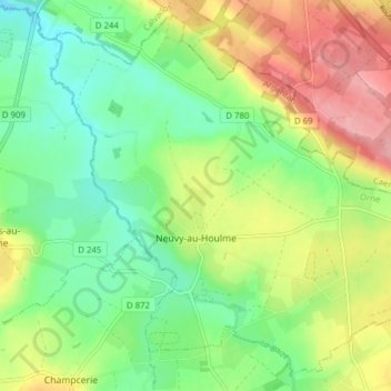
Name: Topografische Karte Neuvy-au-Houlme, Höhe, Relief.
Durchschnittliche Höhe: 192 m
Minimale Höhe: 145 m
Maximale Höhe: 263 m
Andere topografische Karten
Klicken Sie auf eine Karte, um ihre Topografie, ihre Höhe und ihr Relief anzuzeigen.
Tinchebray
France > Normandy > Orne > Tinchebray-Bocage
Tinchebray, Tinchebray-Bocage, Argentan, Orne, Normandy, Metropolitan France, 61800, France
Durchschnittliche Höhe: 238 m
Saint-Langis-lès-Mortagne
France > Normandy > Orne > Saint-Langis-lès-Mortagne
Saint-Langis-lès-Mortagne, Mortagne-au-Perche, Orne, Normandy, Metropolitan France, 61400, France
Durchschnittliche Höhe: 206 m
Les Monts-d'Andaine
France > Normandy > Orne > Les Monts-d'Andaine
Les Monts-d'Andaine, Argentan, Orne, Normandy, Metropolitan France, 61600, France
Durchschnittliche Höhe: 244 m
La Perrière
France > Normandy > Orne > Belforêt-en-Perche
La Perrière, Belforêt-en-Perche, Mortagne-au-Perche, Orne, Normandy, Metropolitan France, 61360, France
Durchschnittliche Höhe: 174 m
Tinchebray-Bocage
Tinchebray-Bocage, Argentan, Orne, Normandy, Metropolitan France, 61800, France
Durchschnittliche Höhe: 256 m
Chambois
France > Normandy > Orne > Gouffern en Auge
Chambois, Gouffern en Auge, Argentan, Orne, Normandy, Metropolitan France, 61160, France
Durchschnittliche Höhe: 115 m
Lonlay-l'Abbaye
Lonlay-l'Abbaye, Argentan, Orne, Normandy, Metropolitan France, 61700, France
Durchschnittliche Höhe: 214 m