
Topografische Karte Vanderbijlpark
Interaktive Karte
Klicken Sie auf die Karte, um die Höhe anzuzeigen.
Über diese Karte
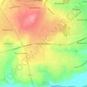
Name: Topografische Karte Vanderbijlpark, Höhe, Relief.
Durchschnittliche Höhe: 1.474 m
Minimale Höhe: 1.421 m
Maximale Höhe: 1.525 m
Vanderbijlpark is situated on the highveld of South Africa, at an altitude of 1,500 meters on the banks of the Vaal River. Summers in the city are warm to hot with an average high between 31 and 35°C, and an average low between 15 and 22°C. Winters in the city are cool to warm with an average high of between 18 and 23°C and an average low of between −1 and 5°C.
Andere topografische Karten
Klicken Sie auf eine Karte, um ihre Topografie, ihre Höhe und ihr Relief anzuzeigen.
Evaton
South Africa > Gauteng > Sedibeng District Municipality > Emfuleni Local Municipality
Evaton, Emfuleni Local Municipality, Sedibeng District Municipality, Gauteng, South Africa
Durchschnittliche Höhe: 1.522 m
Sebokeng
South Africa > Gauteng > Sedibeng District Municipality > Emfuleni Local Municipality
Sebokeng, Emfuleni Local Municipality, Sedibeng District Municipality, Gauteng, 1984, South Africa
Durchschnittliche Höhe: 1.523 m