
Spenden
Rüste dich für dein nächstes Abenteuer:
Als Amazon-Partner verdient diese Website an qualifizierten Käufen, ohne zusätzliche Kosten für Sie.
Topografische Karte Coto De Caza
Klicken Sie auf die Karte, um die Höhe anzuzeigen.
Spenden
Rüste dich für dein nächstes Abenteuer:
Als Amazon-Partner verdient diese Website an qualifizierten Käufen, ohne zusätzliche Kosten für Sie.
Über diese Karte
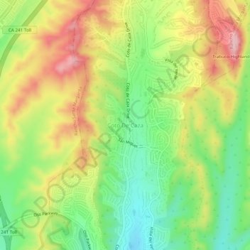
Name: Topografische Karte Coto De Caza, Höhe, Relief.
Durchschnittliche Höhe: 257 m
Minimale Höhe: 163 m
Maximale Höhe: 366 m
Spenden
Rüste dich für dein nächstes Abenteuer:
Als Amazon-Partner verdient diese Website an qualifizierten Käufen, ohne zusätzliche Kosten für Sie.
Andere topografische Karten
Klicken Sie auf eine Karte, um ihre Topografie, ihre Höhe und ihr Relief anzuzeigen.
Newport Beach
United States > California > Orange County
Newport Beach, located in Orange County, California, features a dynamic and varied topography shaped by its coastal position and surrounding hills. The city spans from sea level along its beaches to elevations of over 1,100 feet (335 meters) in the nearby San Joaquin Hills. These hills, particularly noticeable…
Durchschnittliche Höhe: 14 m
Laguna Niguel
United States > California > Orange County
Laguna Niguel consists of mostly hilly terrain, being located within the San Joaquin Hills. The average elevation is 400 feet (120 m); elevations range from near sea level to 936 feet (285 m) at the summit of Niguel Hill, in the southwest corner of the city. Neighboring cities are Aliso Viejo and Laguna Hills…
Durchschnittliche Höhe: 110 m
Spenden
Rüste dich für dein nächstes Abenteuer:
Als Amazon-Partner verdient diese Website an qualifizierten Käufen, ohne zusätzliche Kosten für Sie.
Fullerton
United States > California > Orange County
Fullerton is located at 33°52′48″N 117°55′43″W / 33.88000°N 117.92861°W / 33.88000; -117.92861 (33.879914, -117.928749). It is approximately 25 miles (40 km) southeast of downtown Los Angeles, and approximately 11 miles (18 km) north-northwest of Santa Ana, the county seat. The city has a…
Durchschnittliche Höhe: 79 m
Corona del Mar
United States > California > Orange County > Newport Beach
Durchschnittliche Höhe: 17 m
Spenden
Rüste dich für dein nächstes Abenteuer:
Als Amazon-Partner verdient diese Website an qualifizierten Käufen, ohne zusätzliche Kosten für Sie.
Spenden
Rüste dich für dein nächstes Abenteuer:
Als Amazon-Partner verdient diese Website an qualifizierten Käufen, ohne zusätzliche Kosten für Sie.
Fullerton
United States > California > Orange County
Fullerton is located at 33°52′48″N 117°55′43″W / 33.88000°N 117.92861°W / 33.88000; -117.92861 (33.879914, -117.928749). It is approximately 25 miles (40 km) southeast of downtown Los Angeles, and approximately 11 miles (18 km) north-northwest of Santa Ana, the county seat. The city has a…
Durchschnittliche Höhe: 79 m
Laguna Beach
United States > California > Orange County
The land in and around Laguna Beach rises quickly from the shoreline into the hills and canyons of the San Joaquin Hills. The town's highest point, at an elevation of 1,007 feet (307 m), is Temple Hill in the Top of the World neighborhood. Because of its hilly topography and surrounding parklands, few roads…
Durchschnittliche Höhe: 62 m
Spenden
Rüste dich für dein nächstes Abenteuer:
Als Amazon-Partner verdient diese Website an qualifizierten Käufen, ohne zusätzliche Kosten für Sie.
Mission Viejo
United States > California > Orange County
A very short portion of California State Route 73 travels within Mission Viejo's city limits. There is a Mission Viejo population and elevation road sign directly beneath the northbound onramp that roughly marks the official city limits which travels down the center of Via Escolar to the rail tracks on either…
Durchschnittliche Höhe: 179 m
Spenden
Rüste dich für dein nächstes Abenteuer:
Als Amazon-Partner verdient diese Website an qualifizierten Käufen, ohne zusätzliche Kosten für Sie.
Spenden
Rüste dich für dein nächstes Abenteuer:
Als Amazon-Partner verdient diese Website an qualifizierten Käufen, ohne zusätzliche Kosten für Sie.
Spenden
Rüste dich für dein nächstes Abenteuer:
Als Amazon-Partner verdient diese Website an qualifizierten Käufen, ohne zusätzliche Kosten für Sie.
Spenden
Rüste dich für dein nächstes Abenteuer:
Als Amazon-Partner verdient diese Website an qualifizierten Käufen, ohne zusätzliche Kosten für Sie.
Thousand Steps Beach
United States > California > Orange County > Laguna Beach > South Laguna
Durchschnittliche Höhe: 63 m
Spenden
Rüste dich für dein nächstes Abenteuer:
Als Amazon-Partner verdient diese Website an qualifizierten Käufen, ohne zusätzliche Kosten für Sie.
Spenden
Rüste dich für dein nächstes Abenteuer:
Als Amazon-Partner verdient diese Website an qualifizierten Käufen, ohne zusätzliche Kosten für Sie.
Spenden
Rüste dich für dein nächstes Abenteuer:
Als Amazon-Partner verdient diese Website an qualifizierten Käufen, ohne zusätzliche Kosten für Sie.
Santa Ana
United States > California > Orange County
Santa Ana is nested on flat, low-lying plains with little land elevation change. Running through the west end of the city is the mostly channelized Santa Ana River, which is also largely seasonal due to the construction of the Prado Dam and Seven Oaks Dam. The river caused several severe floods in the 20th…
Durchschnittliche Höhe: 30 m
Laguna Niguel Lake
United States > California > Orange County > Laguna Niguel
Durchschnittliche Höhe: 97 m
Spenden
Rüste dich für dein nächstes Abenteuer:
Als Amazon-Partner verdient diese Website an qualifizierten Käufen, ohne zusätzliche Kosten für Sie.
Spenden
Rüste dich für dein nächstes Abenteuer:
Als Amazon-Partner verdient diese Website an qualifizierten Käufen, ohne zusätzliche Kosten für Sie.
Mission Viejo
United States > California > Orange County
A very short portion of California State Route 73 travels within Mission Viejo's city limits. There is a Mission Viejo population and elevation road sign directly beneath the northbound onramp that roughly marks the official city limits which travels down the center of Via Escolar to the rail tracks on either…
Durchschnittliche Höhe: 179 m
Santa Ana
United States > California > Orange County
Santa Ana is nested on flat, low-lying plains with little land elevation change. Running through the west end of the city is the mostly channelized Santa Ana River, which is also largely seasonal due to the construction of the Prado Dam and Seven Oaks Dam. The river has caused several severe floods in the 20th…
Durchschnittliche Höhe: 30 m
Spenden
Rüste dich für dein nächstes Abenteuer:
Als Amazon-Partner verdient diese Website an qualifizierten Käufen, ohne zusätzliche Kosten für Sie.
Spenden
Rüste dich für dein nächstes Abenteuer:
Als Amazon-Partner verdient diese Website an qualifizierten Käufen, ohne zusätzliche Kosten für Sie.
Laguna Beach
United States > California > Orange County
The land in and around Laguna Beach rises quickly from the shoreline into the hills and canyons of the San Joaquin Hills. The town's highest point, at an elevation of 1,007 feet (307 m), is Temple Hill in the Top of the World neighborhood. Because of its hilly topography and surrounding parklands, few roads…
Durchschnittliche Höhe: 62 m
Spenden
Rüste dich für dein nächstes Abenteuer:
Als Amazon-Partner verdient diese Website an qualifizierten Käufen, ohne zusätzliche Kosten für Sie.
Newport Beach
United States > California > Orange County
Newport Beach extends in elevation from sea level to the 1161 ft (354 m.) summit of Signal Peak in the San Joaquin Hills, but the official elevation is 25 feet (8 m) above sea level at a location of 33°37′0″N 117°53′51″W / 33.61667°N 117.89750°W / 33.61667; -117.89750 (33.616671, −117.897604).
Durchschnittliche Höhe: 14 m
Spenden
Rüste dich für dein nächstes Abenteuer:
Als Amazon-Partner verdient diese Website an qualifizierten Käufen, ohne zusätzliche Kosten für Sie.
Spenden
Rüste dich für dein nächstes Abenteuer:
Als Amazon-Partner verdient diese Website an qualifizierten Käufen, ohne zusätzliche Kosten für Sie.
Laguna Beach
United States > California > Orange County
The land in and around Laguna Beach rises quickly from the shoreline into the hills and canyons of the San Joaquin Hills. The town's highest point, at an elevation of 1,007 feet (307 m), is Temple Hill in the Top of the World neighborhood. Because of its hilly topography and surrounding parklands, few roads…
Durchschnittliche Höhe: 62 m
Newport Beach
United States > California > Orange County
Newport Beach extends in elevation from sea level to the 1,161 ft (354 m) summit of Signal Peak in the San Joaquin Hills, but the official elevation is 25 ft (7.6 m) above sea level at a location of 33°37′0″N 117°53′51″W / 33.61667°N 117.89750°W / 33.61667; -117.89750 (33.616671, −117.897604).
Durchschnittliche Höhe: 14 m
Spenden
Rüste dich für dein nächstes Abenteuer:
Als Amazon-Partner verdient diese Website an qualifizierten Käufen, ohne zusätzliche Kosten für Sie.
Santa Ana
United States > California > Orange County
Santa Ana is nested on flat, low-lying plains with little land elevation change. Running through the west end of the city is the mostly channelized Santa Ana River, which is also largely seasonal due to the construction of the Prado Dam and Seven Oaks Dam. The river caused several severe floods in the 20th…
Durchschnittliche Höhe: 30 m
Newport Beach
United States > California > Orange County
Newport Beach extends in elevation from sea level to the 1,161 ft (354 m) summit of Signal Peak in the San Joaquin Hills, but the official elevation is 25 ft (7.6 m) above sea level at a location of 33°37′0″N 117°53′51″W / 33.61667°N 117.89750°W / 33.61667; -117.89750 (33.616671, −117.897604).
Durchschnittliche Höhe: 14 m
Corona del Mar State Beach
United States > California > Orange County > Newport Beach
Durchschnittliche Höhe: 17 m
Spenden
Rüste dich für dein nächstes Abenteuer:
Als Amazon-Partner verdient diese Website an qualifizierten Käufen, ohne zusätzliche Kosten für Sie.
Laguna Niguel
United States > California > Orange County
Laguna Niguel consists of mostly hilly terrain, being located within the San Joaquin Hills. The average elevation is 400 feet (120 m); elevations range from near sea level to 936 feet (285 m) at the summit of Niguel Hill, in the southwest corner of the city. Neighboring cities are Aliso Viejo and Laguna Hills…
Durchschnittliche Höhe: 110 m
Santa Ana
United States > California > Orange County
Santa Ana is nested on flat, low-lying plains with little land elevation change. Running through the west end of the city is the mostly channelized Santa Ana River, which is also largely seasonal due to the construction of the Prado Dam and Seven Oaks Dam. The river has caused several severe floods in the 20th…
Durchschnittliche Höhe: 30 m
Spenden
Rüste dich für dein nächstes Abenteuer:
Als Amazon-Partner verdient diese Website an qualifizierten Käufen, ohne zusätzliche Kosten für Sie.
Newport Beach
United States > California > Orange County
Newport Beach extends in elevation from sea level to the 1,161 ft (354 m) summit of Signal Peak in the San Joaquin Hills, but the official elevation is 25 ft (7.6 m) above sea level at a location of 33°37′0″N 117°53′51″W / 33.61667°N 117.89750°W / 33.61667; -117.89750 (33.616671, −117.897604).
Durchschnittliche Höhe: 14 m
Laguna Beach
United States > California > Orange County
The land in and around Laguna Beach rises quickly from the shoreline into the hills and canyons of the San Joaquin Hills. The town's highest point, at an elevation of 1,007 feet (307 m), is Temple Hill in the Top of the World neighborhood. Because of its hilly topography and surrounding parklands, few roads…
Durchschnittliche Höhe: 62 m
Spenden
Rüste dich für dein nächstes Abenteuer:
Als Amazon-Partner verdient diese Website an qualifizierten Käufen, ohne zusätzliche Kosten für Sie.
Spenden
Rüste dich für dein nächstes Abenteuer:
Als Amazon-Partner verdient diese Website an qualifizierten Käufen, ohne zusätzliche Kosten für Sie.
Mission Viejo
United States > California > Orange County
A very short portion of California State Route 73 travels within Mission Viejo's city limits. There is a Mission Viejo population and elevation road sign directly beneath the northbound onramp that roughly marks the official city limits which travels down the center of Via Escolar to the rail tracks on either…
Durchschnittliche Höhe: 179 m
Newport Beach
United States > California > Orange County
Newport Beach extends in elevation from sea level to the 1,161 ft (354 m) summit of Signal Peak in the San Joaquin Hills, but the official elevation is 25 ft (7.6 m) above sea level at a location of 33°37′0″N 117°53′51″W / 33.61667°N 117.89750°W / 33.61667; -117.89750 (33.616671, −117.897604).
Durchschnittliche Höhe: 14 m
Spenden
Rüste dich für dein nächstes Abenteuer:
Als Amazon-Partner verdient diese Website an qualifizierten Käufen, ohne zusätzliche Kosten für Sie.