
Topografische Karte Kidwelly
Interaktive Karte
Klicken Sie auf die Karte, um die Höhe anzuzeigen.
Über diese Karte
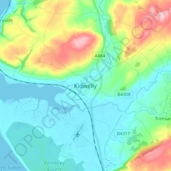
Name: Topografische Karte Kidwelly, Höhe, Relief.
Durchschnittliche Höhe: 52 m
Minimale Höhe: -2 m
Maximale Höhe: 201 m
Andere topografische Karten
Klicken Sie auf eine Karte, um ihre Topografie, ihre Höhe und ihr Relief anzuzeigen.
Carwe / Carway
Royaume-Uni > Pays de Galles > Carmarthenshire
Carwe / Carway, Carmarthenshire, Pays de Galles, SA17 4HL, Royaume-Uni
Durchschnittliche Höhe: 75 m
Carmarthen
Royaume-Uni > Pays de Galles > Carmarthenshire
Carmarthen, Carmarthenshire, Pays de Galles, SA31 1RT, Royaume-Uni
Durchschnittliche Höhe: 74 m
Pentre cwrt
Royaume-Uni > Pays de Galles > Carmarthenshire
Pentre cwrt, Llangeler, Carmarthenshire, Pays de Galles, SA44 5DG, Royaume-Uni
Durchschnittliche Höhe: 122 m
Cross Hands
Royaume-Uni > Pays de Galles > Carmarthenshire
Cross Hands, Carmarthenshire, Pays de Galles, SA14 6NA, Royaume-Uni
Durchschnittliche Höhe: 163 m
Llangadog
Royaume-Uni > Pays de Galles > Carmarthenshire
Llangadog, Carmarthenshire, Pays de Galles, SA19 9AH, Royaume-Uni
Durchschnittliche Höhe: 65 m
Rhosmaen
Royaume-Uni > Pays de Galles > Carmarthenshire > Llandeilo
Rhosmaen, Manordeilo and Salem, Llandeilo, Carmarthenshire, Pays de Galles, SA19 6NP, Royaume-Uni
Durchschnittliche Höhe: 65 m