
Topografische Karte Lough Neagh
Klicken Sie auf die Karte, um die Höhe anzuzeigen.
Über diese Karte
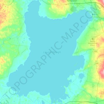
Name: Topografische Karte Lough Neagh, Höhe, Relief.
Ort: Lough Neagh, County Antrim, Northern Ireland, United Kingdom (54.48594 -6.60911 54.75145 -6.22978)
Durchschnittliche Höhe: 29 m
Minimale Höhe: 8 m
Maximale Höhe: 170 m
Andere topografische Karten
Klicken Sie auf eine Karte, um ihre Topografie, ihre Höhe und ihr Relief anzuzeigen.
Ballymoney
United Kingdom > Northern Ireland > County Antrim
In 1837, Lewis's Topographical Dictionary of Ireland, describes Ballymoney as "a market-town and post-town" containing 2,222 inhabitants (11,579 in the broader civil parish) with a long established linen market chiefly supplying the London market, and with "a very extensive trade ... in grain, butter, pork,…
Durchschnittliche Höhe: 51 m
Botanic Gardens
United Kingdom > Northern Ireland > County Antrim > Belfast
Durchschnittliche Höhe: 15 m
Loughgiel Millennium Centre
United Kingdom > Northern Ireland > County Antrim > Loughguile
Durchschnittliche Höhe: 155 m
Magheramorne
United Kingdom > Northern Ireland > County Antrim > Craigstown Meadow
Durchschnittliche Höhe: 32 m
Lagan Navigation (Abandoned)
United Kingdom > Northern Ireland > County Antrim > Belfast
Durchschnittliche Höhe: 29 m
Garron Plateau Blanket Bog
United Kingdom > Northern Ireland > County Antrim
Durchschnittliche Höhe: 323 m
McArt's Fort
United Kingdom > Northern Ireland > County Antrim > Belfast
Durchschnittliche Höhe: 165 m
Kinbane Castle
United Kingdom > Northern Ireland > County Antrim > Ballycastle
Durchschnittliche Höhe: 37 m