
Topografische Karte Buzău
Interaktive Karte
Klicken Sie auf die Karte, um die Höhe anzuzeigen.
Buzău
The city is located in the center of the county, 100 km north-east of Bucharest, in the south-east of Romania, taking up a total area of 81,3 km2, at the outermost curvature of the Subcarpathian foothills, at the crossroads of the three main Romanian historical provinces: Wallachia, Transylvania and Moldavia. It is entirely placed on the right bank of Buzău river, which forms its northern limit. The shape of the city is oblong, longer along the river and shorter across. It reaches altitudes of 101 meters in the north-west, near the foothills, going down to 88 meters on the riverbank, while the average altitude of 95 meters is the same as the altitude of Dacia square, in the city center. Thus, Buzău is placed in a flat area, with a height difference of just 10 meters along a 4-kilometer line.
Über diese Karte
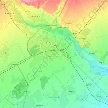
Name: Topografische Karte Buzău, Höhe, Relief.
Ort: Buzău, Romania (45.09161 26.71469 45.18375 26.92587)
Durchschnittliche Höhe: 96 m
Minimale Höhe: 66 m
Maximale Höhe: 152 m
Andere topografische Karten
Klicken Sie auf eine Karte, um ihre Topografie, ihre Höhe und ihr Relief anzuzeigen.