Geolokalisieren

Topografische Karte Seething

Klicken Sie auf die Karte, um die Höhe anzuzeigen.

Über diese Karte

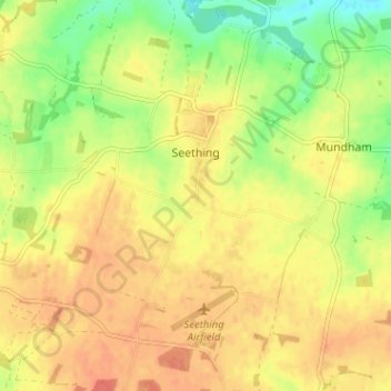
Name: Topografische Karte Seething, Höhe, Relief.

Ort: Seething, South Norfolk, Norfolk, England, United Kingdom (52.50294 1.38908 52.54177 1.42947)

Durchschnittliche Höhe: 31 m

Minimale Höhe: 5 m

Maximale Höhe: 46 m

Andere topografische Karten

Klicken Sie auf eine Karte, um ihre Topografie, ihre Höhe und ihr Relief anzuzeigen.

Welborne

United Kingdom > England > Norfolk > South Norfolk

Durchschnittliche Höhe: 48 m

Harleston

United Kingdom > England > Norfolk > South Norfolk

Durchschnittliche Höhe: 37 m

Morningthorpe

United Kingdom > England > Norfolk > South Norfolk

Durchschnittliche Höhe: 46 m

Morley St Peter

United Kingdom > England > Norfolk > South Norfolk

Durchschnittliche Höhe: 48 m

Thorpe Abbotts

United Kingdom > England > Norfolk > South Norfolk

Durchschnittliche Höhe: 40 m

Hapton

United Kingdom > England > Norfolk > South Norfolk

Durchschnittliche Höhe: 37 m

Kirby Row

United Kingdom > England > Norfolk > South Norfolk > Kirby Cane

Durchschnittliche Höhe: 16 m

Thurlton Links

United Kingdom > England > Norfolk > South Norfolk > Thurlton

Durchschnittliche Höhe: 14 m

Hethel

United Kingdom > England > Norfolk > South Norfolk

Durchschnittliche Höhe: 47 m

Sneath Common

United Kingdom > England > Norfolk > South Norfolk

Durchschnittliche Höhe: 51 m

Keswick

United Kingdom > England > Norfolk > South Norfolk

Durchschnittliche Höhe: 23 m

Tharston

United Kingdom > England > Norfolk > South Norfolk

Durchschnittliche Höhe: 37 m

Highoak

United Kingdom > England > Norfolk > South Norfolk > Morley St Botolph

Durchschnittliche Höhe: 47 m

Caistor St Edmund

United Kingdom > England > Norfolk > South Norfolk

Durchschnittliche Höhe: 28 m

Trowse

United Kingdom > England > Norfolk > South Norfolk

Durchschnittliche Höhe: 23 m

Marlingford

United Kingdom > England > Norfolk > South Norfolk

Durchschnittliche Höhe: 34 m

Chapel Hill

United Kingdom > England > Norfolk > South Norfolk

Durchschnittliche Höhe: 18 m

Beckhithe

United Kingdom > England > Norfolk > South Norfolk > Little Melton > Beckhithe

Durchschnittliche Höhe: 37 m

Tivetshall St Margaret

United Kingdom > England > Norfolk > South Norfolk

Durchschnittliche Höhe: 49 m

Lushbush

United Kingdom > England > Norfolk > South Norfolk > Harleston

Durchschnittliche Höhe: 33 m

Fersfield

United Kingdom > England > Norfolk > South Norfolk > Fersfield

Durchschnittliche Höhe: 45 m

Tivetshall St Mary

United Kingdom > England > Norfolk > South Norfolk

Durchschnittliche Höhe: 46 m

Deopham Green

United Kingdom > England > Norfolk > South Norfolk > Deopham

Durchschnittliche Höhe: 51 m

Harleston

United Kingdom > England > Norfolk > South Norfolk

Durchschnittliche Höhe: 37 m

Thorpe Abbotts

United Kingdom > England > Norfolk > South Norfolk

Durchschnittliche Höhe: 40 m

Surlingham

United Kingdom > England > Norfolk > South Norfolk

Durchschnittliche Höhe: 12 m

Rüste dich für dein nächstes Abenteuer:

🧥Wärmende Fleecejacke - Die perfekte Zwischenschicht (Midlayer) für das Zwiebelprinzip
👟Wandersandalen - Bequemlichkeit für leichte Wege und Furten von Bächen
😴Selbstaufblasende Isomatte - Schutz vor Bodenkälte und unebenem Untergrund
🧣Multifunktionstuch - Schutz für Hals, Kopf oder Gesicht gegen Wind und Sonne
📱Smartphone-Halterung Wandern - Sicherer Zugriff auf digitale Karten direkt am Rucksackgurt

Als Amazon-Partner verdient diese Website an qualifizierten Käufen, ohne zusätzliche Kosten für Sie.