
Topografische Karte Banilad Streetscape
Interaktive Karte
Klicken Sie auf die Karte, um die Höhe anzuzeigen.
Über diese Karte
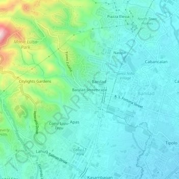
Name: Topografische Karte Banilad Streetscape, Höhe, Relief.
Durchschnittliche Höhe: 68 m
Minimale Höhe: 4 m
Maximale Höhe: 311 m
Andere topografische Karten
Klicken Sie auf eine Karte, um ihre Topografie, ihre Höhe und ihr Relief anzuzeigen.
Pamutan Grassland
Philippines > Cebu City > Pamutan > Mahayahay
Pamutan Grassland, Mahayahay, Pamutan, Cebu City, Central Visayas, Philippines
Durchschnittliche Höhe: 374 m
Pamutan
Pamutan, Cebu City, Central Visayas, Philippines
Durchschnittliche Höhe: 356 m
Sirao Peak
Sirao Peak, Cebu City, Central Visayas, Philippines
Durchschnittliche Höhe: 493 m
Pung-ol Peak
Pung-ol Peak, Cebu City, Central Visayas, Philippines
Durchschnittliche Höhe: 496 m
Bocawe
Philippines > Cebu City > Bocawe
Bocawe, Cebu City, Central Visayas, Philippines
Durchschnittliche Höhe: 407 m
Bulacao Pardo
Philippines > Cebu City > Bulacao Pardo
Bulacao Pardo, Cebu City, Central Visayas, 6045, Philippines
Durchschnittliche Höhe: 69 m
Mountain View
Philippines > Cebu City > Malubog > Tiguib
Mountain View, Cebu Tops Road, Tiguib, Malubog, Cebu City, Central Visayas, Philippines
Durchschnittliche Höhe: 420 m
Piazza Elesia
Philippines > Cebu City > Piazza Elesia
Piazza Elesia, Cebu City, Central Visayas, 653, Philippines
Durchschnittliche Höhe: 69 m