
Topografische Karte Leland
Interaktive Karte
Klicken Sie auf die Karte, um die Höhe anzuzeigen.
Über diese Karte
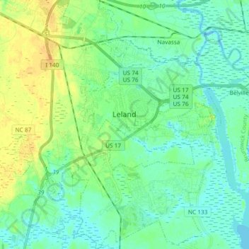
Name: Topografische Karte Leland, Höhe, Relief.
Ort: Leland, Brunswick County, North Carolina, United States (34.15455 -78.10933 34.27584 -77.98050)
Durchschnittliche Höhe: 8 m
Minimale Höhe: -2 m
Maximale Höhe: 24 m
Andere topografische Karten
Klicken Sie auf eine Karte, um ihre Topografie, ihre Höhe und ihr Relief anzuzeigen.
Oak Island
United States > North Carolina > Brunswick County > Oak Island
Oak Island, Brunswick County, North Carolina, 28465, United States
Durchschnittliche Höhe: 4 m
Shallotte
United States > North Carolina > Brunswick County > Shallotte
Shallotte, Brunswick County, North Carolina, United States
Durchschnittliche Höhe: 10 m