
Spenden
Rüste dich für dein nächstes Abenteuer:
Als Amazon-Partner verdient diese Website an qualifizierten Käufen, ohne zusätzliche Kosten für Sie.
Topografische Karte Burnley
Klicken Sie auf die Karte, um die Höhe anzuzeigen.
Spenden
Rüste dich für dein nächstes Abenteuer:
Als Amazon-Partner verdient diese Website an qualifizierten Käufen, ohne zusätzliche Kosten für Sie.
Burnley
The town lies in a natural three-forked valley at the confluence of the River Brun and the River Calder, surrounded by open fields, with wild moorland at higher altitudes. To the west of Burnley lie the towns of Padiham, Accrington and Blackburn, with Nelson and Colne to the north. The centre of the town stands at approximately 387 feet (118 m) above sea level and 30 miles (48 km) east of the Irish Sea coast.
Spenden
Rüste dich für dein nächstes Abenteuer:
Als Amazon-Partner verdient diese Website an qualifizierten Käufen, ohne zusätzliche Kosten für Sie.
Über diese Karte
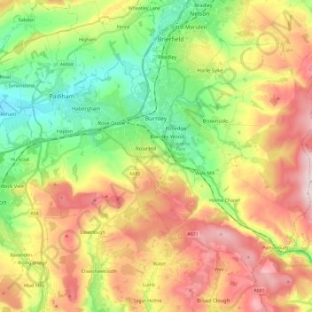
Name: Topografische Karte Burnley, Höhe, Relief.
Ort: Burnley, Lancashire, England, United Kingdom (53.72300 -2.34231 53.82526 -2.11228)
Durchschnittliche Höhe: 247 m
Minimale Höhe: 63 m
Maximale Höhe: 479 m
Spenden
Rüste dich für dein nächstes Abenteuer:
Als Amazon-Partner verdient diese Website an qualifizierten Käufen, ohne zusätzliche Kosten für Sie.
Andere topografische Karten
Klicken Sie auf eine Karte, um ihre Topografie, ihre Höhe und ihr Relief anzuzeigen.
Spenden
Rüste dich für dein nächstes Abenteuer:
Als Amazon-Partner verdient diese Website an qualifizierten Käufen, ohne zusätzliche Kosten für Sie.
Beach Lighthouse
United Kingdom > England > Lancashire > Borough of Wyre > Fleetwood
Durchschnittliche Höhe: 3 m
Spenden
Rüste dich für dein nächstes Abenteuer:
Als Amazon-Partner verdient diese Website an qualifizierten Käufen, ohne zusätzliche Kosten für Sie.
Spenden
Rüste dich für dein nächstes Abenteuer:
Als Amazon-Partner verdient diese Website an qualifizierten Käufen, ohne zusätzliche Kosten für Sie.
Spenden
Rüste dich für dein nächstes Abenteuer:
Als Amazon-Partner verdient diese Website an qualifizierten Käufen, ohne zusätzliche Kosten für Sie.
Bury Hey Wood
United Kingdom > England > Lancashire > West Lancashire > Appley Bridge > Robin Hood
Durchschnittliche Höhe: 106 m
Spenden
Rüste dich für dein nächstes Abenteuer:
Als Amazon-Partner verdient diese Website an qualifizierten Käufen, ohne zusätzliche Kosten für Sie.
Rake Head
United Kingdom > England > Lancashire > Borough of Rossendale > Stacksteads
Durchschnittliche Höhe: 315 m
Houghton Hagg Wood
United Kingdom > England > Lancashire > Burnley > Worsthorne
Durchschnittliche Höhe: 192 m
Lad Law (Boulsworth Hill)
United Kingdom > England > Lancashire > Borough of Pendle
Durchschnittliche Höhe: 409 m
Spenden
Rüste dich für dein nächstes Abenteuer:
Als Amazon-Partner verdient diese Website an qualifizierten Käufen, ohne zusätzliche Kosten für Sie.
Accrington
United Kingdom > England > Lancashire > Hyndburn
Geographical coordinates: 53° 46' 0" North, 2° 21' 0" West. Height above sea level: there is a spot height outside the Market Hall which is 133.5 metres (438 ft) the benchmark on the side of the neighbouring Town Hall is 441.10 feet (134.45 m). The highest height in the town is 320 metres (1,050 ft) which is…
Durchschnittliche Höhe: 199 m
Spenden
Rüste dich für dein nächstes Abenteuer:
Als Amazon-Partner verdient diese Website an qualifizierten Käufen, ohne zusätzliche Kosten für Sie.
Spenden
Rüste dich für dein nächstes Abenteuer:
Als Amazon-Partner verdient diese Website an qualifizierten Käufen, ohne zusätzliche Kosten für Sie.
Brockholes Visitor Village
United Kingdom > England > Lancashire > Preston
Durchschnittliche Höhe: 32 m
Rishton
United Kingdom > England > Lancashire > Hyndburn
Rishton is situated in an area of low moorland north east of Blackburn and north west of Accrington. Its elevation above sea level varies from 250 feet (76 m) in the east, where Norden Brook flows into the River Hyndburn, to 785 feet (239 m) on Rishton Height, north west of the town.
Durchschnittliche Höhe: 151 m
Spenden
Rüste dich für dein nächstes Abenteuer:
Als Amazon-Partner verdient diese Website an qualifizierten Käufen, ohne zusätzliche Kosten für Sie.
Haslingden Grane
United Kingdom > England > Lancashire > Borough of Rossendale
Durchschnittliche Höhe: 305 m
Spenden
Rüste dich für dein nächstes Abenteuer:
Als Amazon-Partner verdient diese Website an qualifizierten Käufen, ohne zusätzliche Kosten für Sie.
Haslingden
United Kingdom > England > Lancashire > Borough of Rossendale
Durchschnittliche Höhe: 275 m
Spenden
Rüste dich für dein nächstes Abenteuer:
Als Amazon-Partner verdient diese Website an qualifizierten Käufen, ohne zusätzliche Kosten für Sie.
Newton-with-Scales
United Kingdom > England > Lancashire > Borough of Fylde
Durchschnittliche Höhe: 16 m
Dowbridge
United Kingdom > England > Lancashire > Borough of Fylde > Treales
Durchschnittliche Höhe: 20 m
Stake Pool
United Kingdom > England > Lancashire > Borough of Wyre > Pilling
Durchschnittliche Höhe: 6 m
Spenden
Rüste dich für dein nächstes Abenteuer:
Als Amazon-Partner verdient diese Website an qualifizierten Käufen, ohne zusätzliche Kosten für Sie.
Spenden
Rüste dich für dein nächstes Abenteuer:
Als Amazon-Partner verdient diese Website an qualifizierten Käufen, ohne zusätzliche Kosten für Sie.
Deeply Vale
United Kingdom > England > Lancashire > Borough of Rossendale
Durchschnittliche Höhe: 231 m
Spenden
Rüste dich für dein nächstes Abenteuer:
Als Amazon-Partner verdient diese Website an qualifizierten Käufen, ohne zusätzliche Kosten für Sie.
Ribby
United Kingdom > England > Lancashire > Borough of Fylde > Wrea Green
Durchschnittliche Höhe: 24 m
Spenden
Rüste dich für dein nächstes Abenteuer:
Als Amazon-Partner verdient diese Website an qualifizierten Käufen, ohne zusätzliche Kosten für Sie.
Roach Bridge
United Kingdom > England > Lancashire > South Ribble > Coupe Green
Durchschnittliche Höhe: 49 m
Cowm Reservoir
United Kingdom > England > Lancashire > Borough of Rossendale > Whitworth > Shawforth
Durchschnittliche Höhe: 302 m
Spenden
Rüste dich für dein nächstes Abenteuer:
Als Amazon-Partner verdient diese Website an qualifizierten Käufen, ohne zusätzliche Kosten für Sie.
Accrington
United Kingdom > England > Lancashire > Hyndburn
Geographical coordinates: 53° 46' 0" North, 2° 21' 0" West. Height above sea level: there is a spot height outside the Market Hall which is 133.5 metres (438 ft) the benchmark on the side of the neighbouring Town Hall is 441.10 feet (134.45 m). The highest height in the town is 320 metres (1,050 ft) which is…
Durchschnittliche Höhe: 199 m
Spenden
Rüste dich für dein nächstes Abenteuer:
Als Amazon-Partner verdient diese Website an qualifizierten Käufen, ohne zusätzliche Kosten für Sie.
Spenden
Rüste dich für dein nächstes Abenteuer:
Als Amazon-Partner verdient diese Website an qualifizierten Käufen, ohne zusätzliche Kosten für Sie.
Scarth Hill
United Kingdom > England > Lancashire > West Lancashire > Ormskirk
Durchschnittliche Höhe: 58 m
Nun Hills
United Kingdom > England > Lancashire > Borough of Rossendale > Stacksteads
Durchschnittliche Höhe: 316 m
Spenden
Rüste dich für dein nächstes Abenteuer:
Als Amazon-Partner verdient diese Website an qualifizierten Käufen, ohne zusätzliche Kosten für Sie.
Spenden
Rüste dich für dein nächstes Abenteuer:
Als Amazon-Partner verdient diese Website an qualifizierten Käufen, ohne zusätzliche Kosten für Sie.
Silverdale Green
United Kingdom > England > Lancashire > Lancaster > Silverdale
Durchschnittliche Höhe: 24 m
Spenden
Rüste dich für dein nächstes Abenteuer:
Als Amazon-Partner verdient diese Website an qualifizierten Käufen, ohne zusätzliche Kosten für Sie.
Forest Holme
United Kingdom > England > Lancashire > Borough of Rossendale > Water
Durchschnittliche Höhe: 318 m
Spenden
Rüste dich für dein nächstes Abenteuer:
Als Amazon-Partner verdient diese Website an qualifizierten Käufen, ohne zusätzliche Kosten für Sie.
Haslingden Grane
United Kingdom > England > Lancashire > Borough of Rossendale > Haslingden
Durchschnittliche Höhe: 287 m
Colne Water
United Kingdom > England > Lancashire > Borough of Pendle > Laneshaw Bridge
Durchschnittliche Höhe: 202 m
Rivington Pike
United Kingdom > England > Lancashire > Chorley > Rivington
Durchschnittliche Höhe: 270 m
Spenden
Rüste dich für dein nächstes Abenteuer:
Als Amazon-Partner verdient diese Website an qualifizierten Käufen, ohne zusätzliche Kosten für Sie.
Lower Bartle
United Kingdom > England > Lancashire > Preston > Woodplumpton
Durchschnittliche Höhe: 30 m
Fold Head
United Kingdom > England > Lancashire > Borough of Rossendale > Healey
Durchschnittliche Höhe: 294 m
Catlow
United Kingdom > England > Lancashire > Borough of Pendle > Nelson
Durchschnittliche Höhe: 243 m
Spenden
Rüste dich für dein nächstes Abenteuer:
Als Amazon-Partner verdient diese Website an qualifizierten Käufen, ohne zusätzliche Kosten für Sie.
Trough Gate
United Kingdom > England > Lancashire > Borough of Rossendale > Britannia
Durchschnittliche Höhe: 341 m
Spenden
Rüste dich für dein nächstes Abenteuer:
Als Amazon-Partner verdient diese Website an qualifizierten Käufen, ohne zusätzliche Kosten für Sie.