
Spenden
Rüste dich für dein nächstes Abenteuer:
Als Amazon-Partner verdient diese Website an qualifizierten Käufen, ohne zusätzliche Kosten für Sie.
Topografische Karte Turlock
Klicken Sie auf die Karte, um die Höhe anzuzeigen.
Spenden
Rüste dich für dein nächstes Abenteuer:
Als Amazon-Partner verdient diese Website an qualifizierten Käufen, ohne zusätzliche Kosten für Sie.
Turlock
Turlock lies in Stanislaus County, at 37°30′21″N 120°50′56″W / 37.50583°N 120.84889°W / 37.50583; -120.84889 (37.505725, −120.849019), between the cities of Modesto and Merced, at the intersection of State Route 99 and State Route 165. Its elevation is about 31 m (101 ft) above MSL. According to the United States Census Bureau, the town has a total area of 16.9 square miles (44 km2), all of it land.
Spenden
Rüste dich für dein nächstes Abenteuer:
Als Amazon-Partner verdient diese Website an qualifizierten Käufen, ohne zusätzliche Kosten für Sie.
Über diese Karte
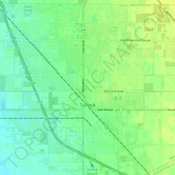
Name: Topografische Karte Turlock, Höhe, Relief.
Ort: Turlock, Stanislaus County, California, United States (37.46609 -120.90367 37.53753 -120.81210)
Durchschnittliche Höhe: 34 m
Minimale Höhe: 26 m
Maximale Höhe: 41 m
Spenden
Rüste dich für dein nächstes Abenteuer:
Als Amazon-Partner verdient diese Website an qualifizierten Käufen, ohne zusätzliche Kosten für Sie.
Andere topografische Karten
Klicken Sie auf eine Karte, um ihre Topografie, ihre Höhe und ihr Relief anzuzeigen.
Oakdale
United States > California > Stanislaus County > Oakdale
Historically the area has been used for orchards and other agricultural uses. Some of the common soil types found in Oakdale are Delhi sand, Oakdale sandy loam, Hanford sandy loam, and Tujunga loamy sand. Oakdale is generally on level ground at an elevation of approximately 190 feet (58 m) above mean sea…
Durchschnittliche Höhe: 66 m