
Topografische Karte Westminster
Interaktive Karte
Klicken Sie auf die Karte, um die Höhe anzuzeigen.
Über diese Karte
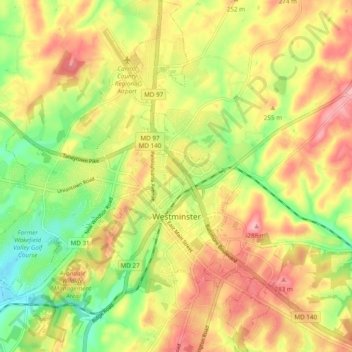
Name: Topografische Karte Westminster, Höhe, Relief.
Ort: Westminster, Carroll County, Maryland, United States (39.54647 -77.04708 39.62053 -76.95920)
Durchschnittliche Höhe: 226 m
Minimale Höhe: 159 m
Maximale Höhe: 290 m
Westminster lies in the humid subtropical climate zone, with hot and humid summers and cool winters with highly variable seasonal snowfall. Due to its elevation, distance from the Chesapeake Bay and urban heat island, temperatures in Westminster are often considerably lower than in Baltimore, especially at night.
Andere topografische Karten
Klicken Sie auf eine Karte, um ihre Topografie, ihre Höhe und ihr Relief anzuzeigen.
Mount Airy
United States > Maryland > Carroll County
Mount Airy, Carroll County, Maryland, 21771, United States
Durchschnittliche Höhe: 221 m
Bear Branch
United States > Maryland > Carroll County > Brown Heights
Bear Branch, Brown Heights, Carroll County, Maryland, United States
Durchschnittliche Höhe: 145 m
Belle Grove Square
United States > Maryland > Carroll County > Westminster
Belle Grove Square, Westminster, Carroll County, Maryland, 21157, United States
Durchschnittliche Höhe: 224 m
Finksburg
United States > Maryland > Carroll County
Finksburg, Carroll County, Maryland, 21048, United States
Durchschnittliche Höhe: 158 m
Hampstead
United States > Maryland > Carroll County
Hampstead, Carroll County, Maryland, United States
Durchschnittliche Höhe: 242 m
New Windsor
United States > Maryland > Carroll County
New Windsor, Carroll County, Maryland, United States
Durchschnittliche Höhe: 154 m
Eldersburg
United States > Maryland > Carroll County
Eldersburg, Carroll County, Maryland, 21784, United States
Durchschnittliche Höhe: 166 m
Keymar
United States > Maryland > Carroll County
Keymar, Carroll County, Maryland, 21757, United States
Durchschnittliche Höhe: 128 m
Gaither
United States > Maryland > Carroll County
Gaither, Carroll County, Maryland, 21784, United States
Durchschnittliche Höhe: 161 m
Union Bridge
United States > Maryland > Carroll County
Union Bridge, Carroll County, Maryland, United States
Durchschnittliche Höhe: 138 m
Avondale Wildlife Management Area
United States > Maryland > Carroll County > Chapel Heights
Avondale Wildlife Management Area, Chapel Heights, Carroll County, Maryland, United States
Durchschnittliche Höhe: 206 m
Melrose
United States > Maryland > Carroll County
Melrose, Carroll County, Maryland, United States
Durchschnittliche Höhe: 262 m
Heritage
United States > Maryland > Carroll County
Heritage, Carroll County, Maryland, United States
Durchschnittliche Höhe: 214 m
Washington Heights
United States > Maryland > Carroll County > Westminster
Washington Heights, Westminster, Carroll County, Maryland, 21157, United States
Durchschnittliche Höhe: 233 m
Taneytown
United States > Maryland > Carroll County
Taneytown, Carroll County, Maryland, 21787, United States
Durchschnittliche Höhe: 153 m
Millers
United States > Maryland > Carroll County
Millers, Carroll County, Maryland, 21102, United States
Durchschnittliche Höhe: 266 m
Union Mills Homestead Park
United States > Maryland > Carroll County > Union Mills
Union Mills Homestead Park, Union Mills, Carroll County, Maryland, United States
Durchschnittliche Höhe: 195 m
Furnace Hills
United States > Maryland > Carroll County > Westminster
Furnace Hills, Westminster, Carroll County, Maryland, 21157, United States
Durchschnittliche Höhe: 211 m
Marston
United States > Maryland > Carroll County
Marston, Carroll County, Maryland, 21776, United States
Durchschnittliche Höhe: 189 m
Liberty Reservoir
United States > Maryland > Carroll County
Liberty Reservoir, Carroll County, Maryland, United States
Durchschnittliche Höhe: 170 m
Cape Horn South
United States > Maryland > Carroll County
Cape Horn South, Carroll County, Maryland, United States
Durchschnittliche Höhe: 256 m
Meadow Brook
United States > Maryland > Carroll County > Taneytown
Meadow Brook, Taneytown, Carroll County, Maryland, 21787, United States
Durchschnittliche Höhe: 156 m
Woodbine
United States > Maryland > Carroll County
Woodbine, Carroll County, Maryland, 21797, United States
Durchschnittliche Höhe: 182 m
Mill Stream Hills
United States > Maryland > Carroll County
Mill Stream Hills, Carroll County, Maryland, 21088, United States
Durchschnittliche Höhe: 238 m
Silver Run
United States > Maryland > Carroll County
Silver Run, Carroll County, Maryland, United States
Durchschnittliche Höhe: 198 m
Eldersburg
United States > Maryland > Carroll County > Eldersburg
Eldersburg, Carroll County, Maryland, 21784, United States
Durchschnittliche Höhe: 167 m
Forest Hills
United States > Maryland > Carroll County > Forest Hills
Forest Hills, Carroll County, Maryland, 21157, United States
Durchschnittliche Höhe: 227 m
Manchester
United States > Maryland > Carroll County
Manchester, Carroll County, Maryland, United States
Durchschnittliche Höhe: 276 m
Mount Airy
United States > Maryland > Carroll County > Mount Airy > Mount Airy
Mount Airy, Carroll County, Maryland, 21771, United States
Durchschnittliche Höhe: 217 m
Sykesville
United States > Maryland > Carroll County
Sykesville, Carroll County, Maryland, United States
Durchschnittliche Höhe: 152 m
Piney Creek
United States > Maryland > Carroll County
Piney Creek, Carroll County, Maryland, 21787, United States
Durchschnittliche Höhe: 152 m