
Topografische Karte Burfield
Interaktive Karte
Klicken Sie auf die Karte, um die Höhe anzuzeigen.
Über diese Karte
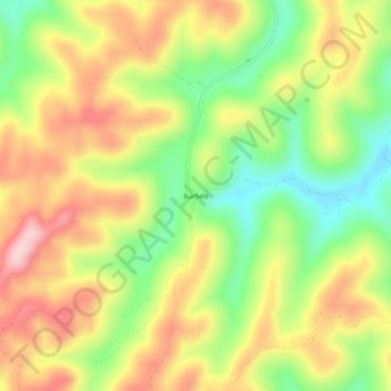
Name: Topografische Karte Burfield, Höhe, Relief.
Ort: Burfield, Wayne County, Kentucky, United States (36.70646 -84.80994 36.74646 -84.76994)
Durchschnittliche Höhe: 380 m
Minimale Höhe: 264 m
Maximale Höhe: 497 m
Andere topografische Karten
Klicken Sie auf eine Karte, um ihre Topografie, ihre Höhe und ihr Relief anzuzeigen.
Buster Hill
United States > Kentucky > Wayne County > Monticello
Buster Hill, Monticello, Wayne County, Kentucky, 42633, United States
Durchschnittliche Höhe: 295 m
Monticello
United States > Kentucky > Wayne County
Monticello, Wayne County, Kentucky, 42633, United States
Durchschnittliche Höhe: 304 m
Frisby
United States > Kentucky > Wayne County
Frisby, Wayne County, Kentucky, United States
Durchschnittliche Höhe: 298 m