
Spenden
Rüste dich für dein nächstes Abenteuer:
Als Amazon-Partner verdient diese Website an qualifizierten Käufen, ohne zusätzliche Kosten für Sie.
Topografische Karte Surguja
Klicken Sie auf die Karte, um die Höhe anzuzeigen.
Spenden
Rüste dich für dein nächstes Abenteuer:
Als Amazon-Partner verdient diese Website an qualifizierten Käufen, ohne zusätzliche Kosten für Sie.
Über diese Karte
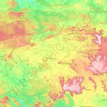
Name: Topografische Karte Surguja, Höhe, Relief.
Ort: Surguja, Surajpur District, Chhattisgarh, India (22.55000 82.30000 23.95000 83.70000)
Durchschnittliche Höhe: 574 m
Minimale Höhe: 272 m
Maximale Höhe: 1.227 m
Spenden
Rüste dich für dein nächstes Abenteuer:
Als Amazon-Partner verdient diese Website an qualifizierten Käufen, ohne zusätzliche Kosten für Sie.
Andere topografische Karten
Klicken Sie auf eine Karte, um ihre Topografie, ihre Höhe und ihr Relief anzuzeigen.
Spenden
Rüste dich für dein nächstes Abenteuer:
Als Amazon-Partner verdient diese Website an qualifizierten Käufen, ohne zusätzliche Kosten für Sie.
Raigarh
India > Chhattisgarh > Raigarh Tahsil
Raigarh is located at 21°54′N 83°24′E / 21.9°N 83.4°E / 21.9; 83.4. It has an average elevation of 215 metres (705 feet). The Kelo river flows through the city, which is one of its main water sources.
Durchschnittliche Höhe: 216 m
Spenden
Rüste dich für dein nächstes Abenteuer:
Als Amazon-Partner verdient diese Website an qualifizierten Käufen, ohne zusätzliche Kosten für Sie.
Indravati National Park
India > Chhattisgarh > Bijapur District
The topography of the park mainly comprises undulating hilly terrain with altitude ranging between 177 and 599 metres above the sea level.
Durchschnittliche Höhe: 253 m
Spenden
Rüste dich für dein nächstes Abenteuer:
Als Amazon-Partner verdient diese Website an qualifizierten Käufen, ohne zusätzliche Kosten für Sie.
Spenden
Rüste dich für dein nächstes Abenteuer:
Als Amazon-Partner verdient diese Website an qualifizierten Käufen, ohne zusätzliche Kosten für Sie.
Spenden
Rüste dich für dein nächstes Abenteuer:
Als Amazon-Partner verdient diese Website an qualifizierten Käufen, ohne zusätzliche Kosten für Sie.
Spenden
Rüste dich für dein nächstes Abenteuer:
Als Amazon-Partner verdient diese Website an qualifizierten Käufen, ohne zusätzliche Kosten für Sie.
Kanker
The northeastern part of Kanker is on the Mahanadi Plane. The majority of this plane lies at an elevation less than 500 meters above sea level. The main river in that area is the Mahanadi River. Hatkul, Chinar, Doodh, Sondur, Nakti, and Toori are the other rivers of the area. Bhanupratappur is located on the…
Durchschnittliche Höhe: 433 m
Spenden
Rüste dich für dein nächstes Abenteuer:
Als Amazon-Partner verdient diese Website an qualifizierten Käufen, ohne zusätzliche Kosten für Sie.
Koriya
Koriya District lies between 22°56′ and 23°48′ North and 81°56′ and 82°47′ East. It is bounded on the north-west by Manendragarh-Chirmiri-Bharatpur district, on the south by Korba District, on the east by Surajpur District. The area of the district is 5977 km2, of which 59.9% is forest area. The…
Durchschnittliche Höhe: 548 m
Spenden
Rüste dich für dein nächstes Abenteuer:
Als Amazon-Partner verdient diese Website an qualifizierten Käufen, ohne zusätzliche Kosten für Sie.
Spenden
Rüste dich für dein nächstes Abenteuer:
Als Amazon-Partner verdient diese Website an qualifizierten Käufen, ohne zusätzliche Kosten für Sie.
Mahasamund
Mahasamund is located at 21°06′N 82°06′E / 21.1°N 82.1°E / 21.1; 82.1. It has an average elevation of 318 metres (1043 feet). Mahasamund is 56 kilometres south-east of Raipur on the junction of National Highway 6 and National Highway 217 close to the Mahanadi River. Mahasamund city is an…
Durchschnittliche Höhe: 299 m
Sukma
This place can easily be a matter of research for the Archaeological department as there exists rare ancient sculptures in this area, one can see a sculpture on which Brahma, Vishnu and Mahesh the Trinity of Hindu faith can be seen on a single stone. Now with the elevation of this area into a new District…
Durchschnittliche Höhe: 256 m
Surajpur
Due to its mountainous topography, the district largely escaped the turmoil of the surrounding plains. The earliest inhabitants are said to be the Kols and Gonds, but there is evidence of more widespread civilization in the region. The rulers of Surguja State were Raksel Rajputs, and were said to have…
Durchschnittliche Höhe: 571 m
Spenden
Rüste dich für dein nächstes Abenteuer:
Als Amazon-Partner verdient diese Website an qualifizierten Käufen, ohne zusätzliche Kosten für Sie.
Spenden
Rüste dich für dein nächstes Abenteuer:
Als Amazon-Partner verdient diese Website an qualifizierten Käufen, ohne zusätzliche Kosten für Sie.