
Topografische Karte Port Royal
Interaktive Karte
Klicken Sie auf die Karte, um die Höhe anzuzeigen.
Über diese Karte
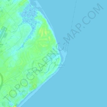
Name: Topografische Karte Port Royal, Höhe, Relief.
Durchschnittliche Höhe: 3 m
Minimale Höhe: -2 m
Maximale Höhe: 13 m
Andere topografische Karten
Klicken Sie auf eine Karte, um ihre Topografie, ihre Höhe und ihr Relief anzuzeigen.
Hilton Head Plantation
United States > South Carolina > Beaufort County > Hilton Head Island
Hilton Head Plantation, Hilton Head Island, Beaufort County, South Carolina, 29926, United States
Durchschnittliche Höhe: 6 m
Skull Creek
United States > South Carolina > Beaufort County > Hilton Head Island
Skull Creek, Hilton Head Island, Beaufort County, South Carolina, 29926, United States
Durchschnittliche Höhe: 3 m