
Topografische Karte Leesburg
Interaktive Karte
Klicken Sie auf die Karte, um die Höhe anzuzeigen.
Über diese Karte
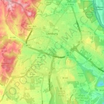
Name: Topografische Karte Leesburg, Höhe, Relief.
Ort: Leesburg, Loudoun County, Virginia, United States (39.06762 -77.60243 39.13853 -77.50793)
Durchschnittliche Höhe: 113 m
Minimale Höhe: 32 m
Maximale Höhe: 215 m
Leesburg is located northeast of the center of Loudoun County at 39°7′N 77°33′W / 39.117°N 77.550°W / 39.117; -77.550 (39.109, −77.558), It is part of the northern Virginia Piedmont and sits at the base of the easternmost chain of the Blue Ridge Mountains, Catoctin Mountain. The town lies in the Culpeper Basin (an inland sea during the Jurassic period) and is adjacent to the valley of the Potomac River, so that the local relief is less pronounced than in other Virginia Piedmont towns. Elevation in town ranges from about 350 to 400 feet (110 to 120 m), with the ridge of Catoctin Mountain rising to 670 feet (200 m) just west of the town limits. The Town Branch of Tuscarora Creek passes through the center of town, flowing east to Goose Creek, a tributary of the Potomac.
Andere topografische Karten
Klicken Sie auf eine Karte, um ihre Topografie, ihre Höhe und ihr Relief anzuzeigen.
Brambleton
United States > Virginia > Loudoun County
Brambleton, Loudoun County, Virginia, 20107, United States
Durchschnittliche Höhe: 99 m
Round Hill
United States > Virginia > Loudoun County > Round Hill
Round Hill, Loudoun County, Virginia, United States
Durchschnittliche Höhe: 177 m
Hamilton
United States > Virginia > Loudoun County > Hamilton
Hamilton, Loudoun County, Virginia, 20159, United States
Durchschnittliche Höhe: 152 m
Conklin
United States > Virginia > Loudoun County > South Riding > Conklin
Conklin, South Riding, Loudoun County, Virginia, 20152, United States
Durchschnittliche Höhe: 92 m
Cascades
United States > Virginia > Loudoun County
Cascades, Loudoun County, Virginia, 20165, United States
Durchschnittliche Höhe: 81 m