
Topografische Karte Camels Hump
Interaktive Karte
Klicken Sie auf die Karte, um die Höhe anzuzeigen.
Über diese Karte
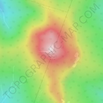
Name: Topografische Karte Camels Hump, Höhe, Relief.
Durchschnittliche Höhe: 843 m
Minimale Höhe: 534 m
Maximale Höhe: 1.223 m
The summit of Camel's Hump is home to 10 acres (4 ha) of alpine tundra vegetation. Common plants found in this area include: Bigelow's sedge (Carex bigelowii), alpine bilberry (Vaccinium uliginosum), mountain sandwort (Minuartia groenlandica), crowberry (Empetrum nigrum), mountain cranberry (Vaccinium vitis-idaea), and Labrador tea (Rhododendron groenlandicum). A direct result of glacial formation, these alpine species were once widespread but as the lower elevations warmed, only the very peak of Camel's Hump remained hospitable to the fragile plants.
Andere topografische Karten
Klicken Sie auf eine Karte, um ihre Topografie, ihre Höhe und ihr Relief anzuzeigen.
Hanksville
United States > Vermont > Chittenden County > Huntington
Hanksville, Huntington, Chittenden County, Vermont, United States
Durchschnittliche Höhe: 426 m