
Topografische Karte Florina
Interaktive Karte
Klicken Sie auf die Karte, um die Höhe anzuzeigen.
Über diese Karte
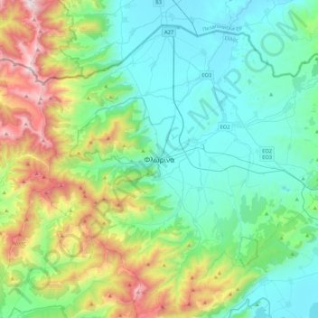
Name: Topografische Karte Florina, Höhe, Relief.
Durchschnittliche Höhe: 999 m
Minimale Höhe: 574 m
Maximale Höhe: 2.319 m
Florina is one of the coldest towns in Greece, because of its elevation and geographic position. Heavy snowfalls, thick fog and below-freezing temperatures are common during the winter months, while the summers are mild. Under the Köppen climate classification, Florina has a humid subtropical climate (Cfa) with strong hot-summer continental climate (Dfa) influences.
Andere topografische Karten
Klicken Sie auf eine Karte, um ihre Topografie, ihre Höhe und ihr Relief anzuzeigen.
Mazi
Greece > Epirus and Western Macedonia > Florina Regional Unit > Prespes Municipal Unit
Mazi, Prespes Municipal Unit, Prespes Municipality, Florina Regional Unit, Western Macedonia, Epirus and Western Macedonia, Greece
Durchschnittliche Höhe: 1.423 m
Melissovouno
Greece > Epirus and Western Macedonia > Florina Regional Unit > Meliti Municipal Unit > Σιταριά
Melissovouno, Σιταριά, Meliti Municipal Unit, Municipality of Florina, Florina Regional Unit, Western Macedonia, Epirus and Western Macedonia, 530 74, Greece
Durchschnittliche Höhe: 634 m
Armenochori
Greece > Epirus and Western Macedonia > Florina Regional Unit
Armenochori, Municipality of Florina, Florina Regional Unit, Western Macedonia, Epirus and Western Macedonia, 531 00, Greece
Durchschnittliche Höhe: 621 m
Drosopigi
Greece > Epirus and Western Macedonia > Florina Regional Unit
Drosopigi, Municipality of Florina, Florina Regional Unit, Western Macedonia, Epirus and Western Macedonia, 531 00, Greece
Durchschnittliche Höhe: 1.040 m