
Topografische Karte Cotahuma
Interaktive Karte
Klicken Sie auf die Karte, um die Höhe anzuzeigen.
Über diese Karte
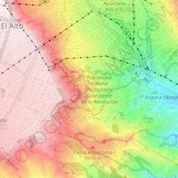
Name: Topografische Karte Cotahuma, Höhe, Relief.
Ort: Cotahuma, La Paz, Pedro Domingo Murillo, La Paz, Bolivie (-16.55441 -68.15668 -16.49639 -68.11534)
Durchschnittliche Höhe: 3.746 m
Minimale Höhe: 3.303 m
Maximale Höhe: 4.104 m
Andere topografische Karten
Klicken Sie auf eine Karte, um ihre Topografie, ihre Höhe und ihr Relief anzuzeigen.
Pequeño Alpamayo
Bolivie > La Paz > Pedro Domingo Murillo > La Paz
Pequeño Alpamayo, La Paz, Pedro Domingo Murillo, La Paz, Bolivie
Durchschnittliche Höhe: 4.927 m
Sur
Bolivie > La Paz > Pedro Domingo Murillo > La Paz
Sur, La Paz, Pedro Domingo Murillo, La Paz, Bolivie
Durchschnittliche Höhe: 3.653 m
Centro
Bolivie > La Paz > Pedro Domingo Murillo > La Paz
Centro, La Paz, Pedro Domingo Murillo, La Paz, Bolivie
Durchschnittliche Höhe: 3.666 m