
Topografische Karte Ranchi
Interaktive Karte
Klicken Sie auf die Karte, um die Höhe anzuzeigen.
Über diese Karte
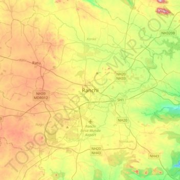
Name: Topografische Karte Ranchi, Höhe, Relief.
Ort: Ranchi, Kanke, Ranchi District, Jharkhand, 834001, India (23.21005 85.16504 23.53005 85.48504)
Durchschnittliche Höhe: 648 m
Minimale Höhe: 458 m
Maximale Höhe: 896 m
Ranchi lies at 23°22′N 85°20′E / 23.36°N 85.33°E / 23.36; 85.33 near to the Tropic of Cancer. The city covers an area of 175 km2 (68 sq mi) and its average elevation is 651 m above sea level. Ranchi is located in the southern part of the Chota Nagpur plateau, which is the eastern section of the Deccan plateau.