
Topografische Karte Thunderbolt
Interaktive Karte
Klicken Sie auf die Karte, um die Höhe anzuzeigen.
Über diese Karte
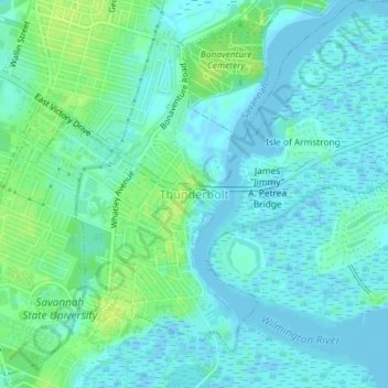
Name: Topografische Karte Thunderbolt, Höhe, Relief.
Ort: Thunderbolt, Chatham County, Georgia, United States (32.02093 -81.06394 32.04606 -81.02741)
Durchschnittliche Höhe: 5 m
Minimale Höhe: -4 m
Maximale Höhe: 14 m
Andere topografische Karten
Klicken Sie auf eine Karte, um ihre Topografie, ihre Höhe und ihr Relief anzuzeigen.
Savannah
United States > Georgia > Chatham County
Savannah, Chatham County, Georgia, United States
Durchschnittliche Höhe: 4 m
Oakdale
United States > Georgia > Chatham County > Savannah
Oakdale, Savannah, Chatham County, Georgia, 31406, United States
Durchschnittliche Höhe: 10 m
Welwood
United States > Georgia > Chatham County > Savannah
Welwood, Savannah, Chatham County, Georgia, 31409, United States
Durchschnittliche Höhe: 7 m
Tybee Island
United States > Georgia > Chatham County
Tybee Island, Chatham County, Georgia, 31328, United States
Durchschnittliche Höhe: 1 m
O'Leary
United States > Georgia > Chatham County > Port Wentworth > O'Leary
O'Leary, Port Wentworth, Chatham County, Georgia, 31407, United States
Durchschnittliche Höhe: 5 m