Topografische Karte Mineral Point
Interaktive Karte
Klicken Sie auf die Karte, um die Höhe anzuzeigen.
Über diese Karte
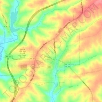
Name: Topografische Karte Mineral Point, Höhe, Relief.
Ort: Mineral Point, Iowa County, Wisconsin, United States (42.84333 -90.21007 42.88394 -90.15772)
Durchschnittliche Höhe: 324 m
Minimale Höhe: 275 m
Maximale Höhe: 364 m
Mineral Point was settled in 1827, becoming a lead and zinc mining center, and commercial town in the 19th and early 20th centuries. In the mid-20th century it attracted artists and an artist's colony and its tourism industry began to grow. The city's well-preserved historical character within the varied natural topography of the driftless area has made it a regional tourist destination. Mineral Point is sometimes called Wisconsin's third oldest city, but the Wisconsin Historical Society notes several older colonial settlements.
Andere topografische Karten
Klicken Sie auf eine Karte, um ihre Topografie, ihre Höhe und ihr Relief anzuzeigen.
Jonesdale
United States > Wisconsin > Iowa County
Jonesdale, Town of Waldwick, Iowa County, Wisconsin, United States
Durchschnittliche Höhe: 306 m
Linden
United States > Wisconsin > Iowa County
Linden, Iowa County, Wisconsin, 53553, United States
Durchschnittliche Höhe: 332 m
Cobb
United States > Wisconsin > Iowa County
Cobb, Iowa County, Wisconsin, 53526, United States
Durchschnittliche Höhe: 359 m
Rewey
United States > Wisconsin > Iowa County
Rewey, Iowa County, Wisconsin, United States
Durchschnittliche Höhe: 333 m
Highland
United States > Wisconsin > Iowa County
Highland, Iowa County, Wisconsin, United States
Durchschnittliche Höhe: 353 m
Arena
United States > Wisconsin > Iowa County
Arena, Iowa County, Wisconsin, United States
Durchschnittliche Höhe: 230 m
Montfort Junction
United States > Wisconsin > Iowa County
Montfort Junction, Town of Eden, Iowa County, Wisconsin, 53569, United States
Durchschnittliche Höhe: 356 m
Edmund
United States > Wisconsin > Iowa County
Edmund, Town of Linden, Iowa County, Wisconsin, 53535, United States
Durchschnittliche Höhe: 351 m
Avoca
United States > Wisconsin > Iowa County
Avoca, Iowa County, Wisconsin, United States
Durchschnittliche Höhe: 217 m
Town of Mineral Point
United States > Wisconsin > Iowa County
Town of Mineral Point, Iowa County, Wisconsin, 53565, United States
Durchschnittliche Höhe: 335 m
Governor Dodge State Park
United States > Wisconsin > Iowa County
Governor Dodge State Park, Town of Dodgeville, Iowa County, Wisconsin, 53533, United States
Durchschnittliche Höhe: 336 m
Tower Hill State Park
United States > Wisconsin > Iowa County > Town of Wyoming
Tower Hill State Park, Town of Wyoming, Iowa County, Wisconsin, United States
Durchschnittliche Höhe: 233 m
Town of Brigham
United States > Wisconsin > Iowa County
Town of Brigham, Iowa County, Wisconsin, 53507, United States
Durchschnittliche Höhe: 330 m
Blue Mound State Park
United States > Wisconsin > Iowa County > Village of Blue Mounds
Blue Mound State Park, Village of Blue Mounds, Town of Brigham, Iowa County, Wisconsin, 53517, United States
Durchschnittliche Höhe: 416 m
Town of Wyoming
United States > Wisconsin > Iowa County
Town of Wyoming, Iowa County, Wisconsin, United States
Durchschnittliche Höhe: 267 m
Ridgeway
United States > Wisconsin > Iowa County
Ridgeway, Iowa County, Wisconsin, United States
Durchschnittliche Höhe: 338 m
Town of Moscow
United States > Wisconsin > Iowa County
Town of Moscow, Iowa County, Wisconsin, 53544, United States
Durchschnittliche Höhe: 293 m
Blue Mounds
United States > Wisconsin > Iowa County
Blue Mounds, Town of Brigham, Iowa County, Wisconsin, 53517, United States
Durchschnittliche Höhe: 417 m
Barneveld
United States > Wisconsin > Iowa County
Barneveld, Iowa County, Wisconsin, United States
Durchschnittliche Höhe: 350 m
Dodgeville
United States > Wisconsin > Iowa County
Dodgeville, Iowa County, Wisconsin, United States
Durchschnittliche Höhe: 369 m
Hollandale
United States > Wisconsin > Iowa County
Hollandale, Iowa County, Wisconsin, United States
Durchschnittliche Höhe: 278 m