
Topografische Karte San Jose del Monte
Interaktive Karte
Klicken Sie auf die Karte, um die Höhe anzuzeigen.
Über diese Karte
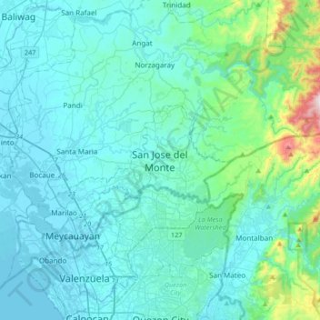
Name: Topografische Karte San Jose del Monte, Höhe, Relief.
Durchschnittliche Höhe: 106 m
Minimale Höhe: -3 m
Maximale Höhe: 981 m
The elevation of the city ranges from approximately 40–900 meters above sea level; the relief transitions from warm lowland to cool upland as one goes eastward. This is because the city is part of the Sierra Madre mountain range. Plains and river valley flats characterize the western and southwestern quadrant. The central portion and much of its eastern section is made up of undulating hills with low relief. High relief areas moderate slopes best describe its extreme eastern and northwestern quadrant. Slopes of 3%-8% are extensively found in the city, particularly on the western half. Slopes of 30%-50% comprise the smallest portion of the total land area.
Andere topografische Karten
Klicken Sie auf eine Karte, um ihre Topografie, ihre Höhe und ihr Relief anzuzeigen.
Marina Lake
Philippines > Bulacan > San Jose del Monte > Sapang Palay Proper
Marina Lake, Sapang Palay Proper, San Jose del Monte, Bulacan, Central Luzon, 3024, Philippines
Durchschnittliche Höhe: 50 m