
Topografische Karte Verhniy Ufaley
Interaktive Karte
Klicken Sie auf die Karte, um die Höhe anzuzeigen.
Über diese Karte
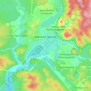
Name: Topografische Karte Verhniy Ufaley, Höhe, Relief.
Durchschnittliche Höhe: 404 m
Minimale Höhe: 347 m
Maximale Höhe: 540 m
Lake Itkul, located at the altitude of 720 meters (2,360 ft) above sea level, is one of the notable natural wonders in Verkhny Ufaley. It is fed by springs, creeks, and small rivers, so its waters renew within a year and are fresh and clean. The lake is clear but has a brownish reflection. The lake and its vicinity have become a popular destination for Verkhny Ufaley's residents and visitors alike.