
Topografische Karte Greenwood
Interaktive Karte
Klicken Sie auf die Karte, um die Höhe anzuzeigen.
Über diese Karte
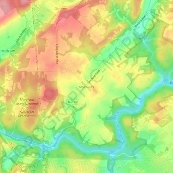
Name: Topografische Karte Greenwood, Höhe, Relief.
Durchschnittliche Höhe: 93 m
Minimale Höhe: 35 m
Maximale Höhe: 148 m
Andere topografische Karten
Klicken Sie auf eine Karte, um ihre Topografie, ihre Höhe und ihr Relief anzuzeigen.
Hydes
United States > Maryland > Baltimore County > Towson
Hydes, Towson, Baltimore County, Maryland, 21013, United States
Durchschnittliche Höhe: 123 m
Brooklandville
United States > Maryland > Baltimore County > Towson
Brooklandville, Towson, Baltimore County, Maryland, 21022, United States
Durchschnittliche Höhe: 122 m
Rockland
United States > Maryland > Baltimore County > Towson
Rockland, Towson, Baltimore County, Maryland, 21022, United States
Durchschnittliche Höhe: 107 m
Towson
United States > Maryland > Baltimore County > Towson
Towson, Baltimore County, Maryland, United States
Durchschnittliche Höhe: 114 m
Long Green
United States > Maryland > Baltimore County > Towson
Long Green, Towson, Baltimore County, Maryland, 21057, United States
Durchschnittliche Höhe: 129 m
Glen Arm
United States > Maryland > Baltimore County > Towson
Glen Arm, Towson, Baltimore County, Maryland, 21057, United States
Durchschnittliche Höhe: 109 m