
Topografische Karte Asotin
Interaktive Karte
Klicken Sie auf die Karte, um die Höhe anzuzeigen.
Über diese Karte
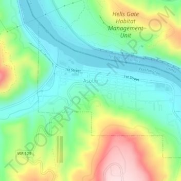
Name: Topografische Karte Asotin, Höhe, Relief.
Ort: Asotin, Asotin County, Washington, 99402, United States (46.32783 -117.05974 46.34787 -117.02315)
Durchschnittliche Höhe: 319 m
Minimale Höhe: 217 m
Maximale Höhe: 519 m
Asotin is located at 46°20′20″N 117°2′47″W / 46.33889°N 117.04639°W / 46.33889; -117.04639 (46.338847, -117.046441). It is a few miles south of Clarkston, on the west bank of the Snake River. The elevation is 801 feet (244 m) above sea level.