
Topografische Karte Agatti Island
Interaktive Karte
Klicken Sie auf die Karte, um die Höhe anzuzeigen.
Über diese Karte
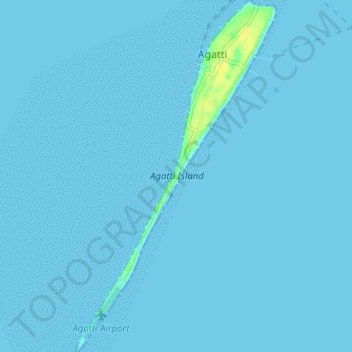
Name: Topografische Karte Agatti Island, Höhe, Relief.
Ort: Agatti Island, Agatti, Lakshadweep, India (10.81638 72.17071 10.87857 72.20679)
Durchschnittliche Höhe: 1 m
Minimale Höhe: 0 m
Maximale Höhe: 17 m
Andere topografische Karten
Klicken Sie auf eine Karte, um ihre Topografie, ihre Höhe und ihr Relief anzuzeigen.
Minicoy Island
India > Lakshadweep > Minicoy > Minicoy
Minicoy Island, Minicoy, Lakshadweep, 682559, India
Durchschnittliche Höhe: 1 m
Kavaratti Island
India > Lakshadweep > Kavaratti > Kavaratti
Kavaratti Island, Kavaratti, Lakshadweep, 262240, India
Durchschnittliche Höhe: 2 m
Kadmat Island
India > Lakshadweep > Kadmat > Kadmat
Kadmat Island, Kadmat, Lakshadweep, India
Durchschnittliche Höhe: 0 m
Kavaratti
India > Lakshadweep > Kavaratti
Kavaratti, Lakshadweep, 262240, India
Durchschnittliche Höhe: 0 m
Bangaram Island
India > Lakshadweep > Agatti
Bangaram Island, Agatti, Lakshadweep, India
Durchschnittliche Höhe: 0 m
Kalpeni Island
India > Lakshadweep > Kalpeni > Kalpeni
Kalpeni Island, Kalpeni, Lakshadweep, India
Durchschnittliche Höhe: 1 m
Kiltān Island
Kiltān Island, Kiltan, Lakshadweep, India
Durchschnittliche Höhe: 2 m
Chetlat Island
Chetlat Island, Chetlat, Lakshadweep, India
Durchschnittliche Höhe: 1 m