
Topografische Karte Nizhny Novgorod
Interaktive Karte
Klicken Sie auf die Karte, um die Höhe anzuzeigen.
Über diese Karte
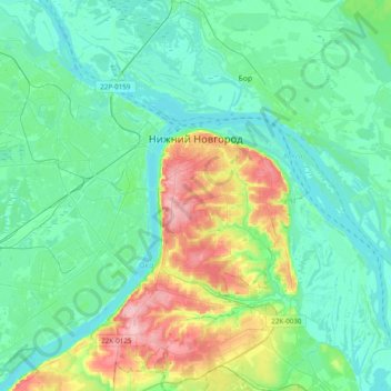
Name: Topografische Karte Nizhny Novgorod, Höhe, Relief.
Durchschnittliche Höhe: 93 m
Minimale Höhe: 59 m
Maximale Höhe: 209 m
Originally the name was just Novgorod ("Newtown"), but to distinguish it from the other, older and well-known Novgorod (Veliky Novgorod) to the west, the city was commonly called "Novgorod of the Lower lands," or "Lower Newtown." This land was named "lower" (nizhniy (нижний)), even though it is actually higher in altitude than Veliky Novgorod, because it is situated downstream of other Russian cities such as Moscow, Vladimir and Murom.
Andere topografische Karten
Klicken Sie auf eine Karte, um ihre Topografie, ihre Höhe und ihr Relief anzuzeigen.
Стрелка
Russia > Nizhny Novgorod Oblast > Nizhny Novgorod > Nizhny Novgorod
Стрелка, Канавинский район, Nizhny Novgorod, Nizhny Novgorod Oblast, Volga Federal District, 603086, Russia
Durchschnittliche Höhe: 76 m
Nizhny Novgorod
Russia > Nizhny Novgorod Oblast > Nizhny Novgorod > Nizhny Novgorod
Nizhny Novgorod, Nizhny Novgorod Oblast, Volga Federal District, 603082, Russia
Durchschnittliche Höhe: 87 m