
Topografische Karte Crawley
Interaktive Karte
Klicken Sie auf die Karte, um die Höhe anzuzeigen.
Über diese Karte
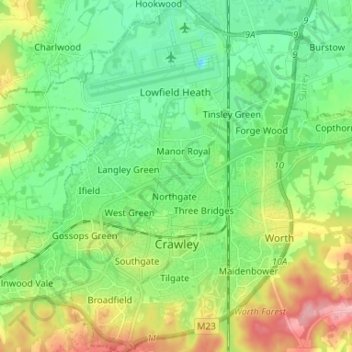
Name: Topografische Karte Crawley, Höhe, Relief.
Ort: Crawley, West Sussex, England, United Kingdom (51.08481 -0.25563 51.16730 -0.13298)
Durchschnittliche Höhe: 80 m
Minimale Höhe: 39 m
Maximale Höhe: 165 m
Crawley lies within the Sussex Weald, an area of highly variable terrain so that many microclimates of frost hollows, sun traps and windswept hilltops will be encountered over a short distance. During calm, clear periods of weather this allows for some interesting temperature variations, although most of the time, when mobile westerly airstreams persist, the weather is typically Oceanic like the rest of the British Isles. Gatwick is the nearest weather station that publishes long-term averages that give an accurate description of the climate of the Crawley area, although more recently the Met Office has also published data for its nearby weather station at Charlwood. Both weather stations are about 3 miles north of Crawley town centre and at similar altitudes.
Andere topografische Karten
Klicken Sie auf eine Karte, um ihre Topografie, ihre Höhe und ihr Relief anzuzeigen.
Compton
United Kingdom > England > West Sussex > Chichester
Compton, Chichester, West Sussex, England, United Kingdom
Durchschnittliche Höhe: 105 m
Felpham
United Kingdom > England > West Sussex > Arun
Felpham, Arun, West Sussex, England, PO22 7PA, United Kingdom
Durchschnittliche Höhe: 2 m
Worthing
United Kingdom > England > West Sussex
Worthing, West Sussex, England, United Kingdom
Durchschnittliche Höhe: 35 m
Shoreham-by-Sea
United Kingdom > England > West Sussex > Adur
Shoreham-by-Sea, Adur, West Sussex, England, BN43 5ZP, United Kingdom
Durchschnittliche Höhe: 25 m
Southbourne
United Kingdom > England > West Sussex > Chichester
Southbourne, Chichester, West Sussex, England, United Kingdom
Durchschnittliche Höhe: 5 m
Petworth
United Kingdom > England > West Sussex > Chichester
Petworth, Chichester, West Sussex, England, United Kingdom
Durchschnittliche Höhe: 46 m
Burgess Hill
United Kingdom > England > West Sussex > Mid Sussex District
Burgess Hill, Mid Sussex District, West Sussex, England, United Kingdom
Durchschnittliche Höhe: 41 m
Lindfield
United Kingdom > England > West Sussex > Mid Sussex District > Lindfield
Lindfield, Mid Sussex District, West Sussex, England, United Kingdom
Durchschnittliche Höhe: 49 m