
Spenden
Rüste dich für dein nächstes Abenteuer:
Als Amazon-Partner verdient diese Website an qualifizierten Käufen, ohne zusätzliche Kosten für Sie.
Topografische Karte Abingdon
Klicken Sie auf die Karte, um die Höhe anzuzeigen.
Spenden
Rüste dich für dein nächstes Abenteuer:
Als Amazon-Partner verdient diese Website an qualifizierten Käufen, ohne zusätzliche Kosten für Sie.
Über diese Karte
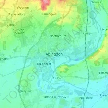
Name: Topografische Karte Abingdon, Höhe, Relief.
Durchschnittliche Höhe: 64 m
Minimale Höhe: 45 m
Maximale Höhe: 136 m
Spenden
Rüste dich für dein nächstes Abenteuer:
Als Amazon-Partner verdient diese Website an qualifizierten Käufen, ohne zusätzliche Kosten für Sie.
Andere topografische Karten
Klicken Sie auf eine Karte, um ihre Topografie, ihre Höhe und ihr Relief anzuzeigen.
Letcombe Bassett
United Kingdom > England > Oxfordshire > Vale of White Horse
Durchschnittliche Höhe: 177 m
Spenden
Rüste dich für dein nächstes Abenteuer:
Als Amazon-Partner verdient diese Website an qualifizierten Käufen, ohne zusätzliche Kosten für Sie.
The Spinney
United Kingdom > England > Oxfordshire > Vale of White Horse > Kingston Bagpuize
Durchschnittliche Höhe: 77 m
Appleford-on-Thames
United Kingdom > England > Oxfordshire > Vale of White Horse
Durchschnittliche Höhe: 51 m
Ashdown Park
United Kingdom > England > Oxfordshire > Vale of White Horse > Ashbury
Durchschnittliche Höhe: 185 m
Spenden
Rüste dich für dein nächstes Abenteuer:
Als Amazon-Partner verdient diese Website an qualifizierten Käufen, ohne zusätzliche Kosten für Sie.
Wytham Woods
United Kingdom > England > Oxfordshire > Vale of White Horse > Farmoor
Durchschnittliche Höhe: 84 m
West Hendred
United Kingdom > England > Oxfordshire > Vale of White Horse
Durchschnittliche Höhe: 121 m
Spenden
Rüste dich für dein nächstes Abenteuer:
Als Amazon-Partner verdient diese Website an qualifizierten Käufen, ohne zusätzliche Kosten für Sie.
Sutton Courtenay
United Kingdom > England > Oxfordshire > Vale of White Horse
Durchschnittliche Höhe: 56 m
Radley
United Kingdom > England > Oxfordshire > Vale of White Horse > Abingdon
Durchschnittliche Höhe: 66 m
Great Coxwell
United Kingdom > England > Oxfordshire > Vale of White Horse > Faringdon
Durchschnittliche Höhe: 108 m
South Hinksey
United Kingdom > England > Oxfordshire > Vale of White Horse
Durchschnittliche Höhe: 83 m
Spenden
Rüste dich für dein nächstes Abenteuer:
Als Amazon-Partner verdient diese Website an qualifizierten Käufen, ohne zusätzliche Kosten für Sie.
East Hendred
United Kingdom > England > Oxfordshire > Vale of White Horse
Durchschnittliche Höhe: 119 m
Farmoor Reservoir
United Kingdom > England > Oxfordshire > Vale of White Horse > Cumnor
Durchschnittliche Höhe: 69 m
Spenden
Rüste dich für dein nächstes Abenteuer:
Als Amazon-Partner verdient diese Website an qualifizierten Käufen, ohne zusätzliche Kosten für Sie.
Besselsleigh
United Kingdom > England > Oxfordshire > Vale of White Horse
Durchschnittliche Höhe: 94 m
Little Lews
United Kingdom > England > Oxfordshire > Vale of White Horse > Ardington
Durchschnittliche Höhe: 183 m
Spenden
Rüste dich für dein nächstes Abenteuer:
Als Amazon-Partner verdient diese Website an qualifizierten Käufen, ohne zusätzliche Kosten für Sie.
Little Coxwell
United Kingdom > England > Oxfordshire > Vale of White Horse
Durchschnittliche Höhe: 111 m
Spenden
Rüste dich für dein nächstes Abenteuer:
Als Amazon-Partner verdient diese Website an qualifizierten Käufen, ohne zusätzliche Kosten für Sie.
Spenden
Rüste dich für dein nächstes Abenteuer:
Als Amazon-Partner verdient diese Website an qualifizierten Käufen, ohne zusätzliche Kosten für Sie.
Compton Beauchamp
United Kingdom > England > Oxfordshire > Vale of White Horse
Durchschnittliche Höhe: 142 m
Spenden
Rüste dich für dein nächstes Abenteuer:
Als Amazon-Partner verdient diese Website an qualifizierten Käufen, ohne zusätzliche Kosten für Sie.
Sunningwell
United Kingdom > England > Oxfordshire > Vale of White Horse > Abingdon
Durchschnittliche Höhe: 96 m
Botley and North Hinksey
United Kingdom > England > Oxfordshire > Vale of White Horse
Durchschnittliche Höhe: 78 m
Spenden
Rüste dich für dein nächstes Abenteuer:
Als Amazon-Partner verdient diese Website an qualifizierten Käufen, ohne zusätzliche Kosten für Sie.
East Challow
United Kingdom > England > Oxfordshire > Vale of White Horse
Durchschnittliche Höhe: 88 m
Spenden
Rüste dich für dein nächstes Abenteuer:
Als Amazon-Partner verdient diese Website an qualifizierten Käufen, ohne zusätzliche Kosten für Sie.
Kingston Lisle
United Kingdom > England > Oxfordshire > Vale of White Horse
Durchschnittliche Höhe: 145 m
Spenden
Rüste dich für dein nächstes Abenteuer:
Als Amazon-Partner verdient diese Website an qualifizierten Käufen, ohne zusätzliche Kosten für Sie.
Shellingford
United Kingdom > England > Oxfordshire > Vale of White Horse
Durchschnittliche Höhe: 85 m
Stanford in the Vale
United Kingdom > England > Oxfordshire > Vale of White Horse
Durchschnittliche Höhe: 79 m
Spenden
Rüste dich für dein nächstes Abenteuer:
Als Amazon-Partner verdient diese Website an qualifizierten Käufen, ohne zusätzliche Kosten für Sie.
Hinton Waldrist
United Kingdom > England > Oxfordshire > Vale of White Horse
Durchschnittliche Höhe: 76 m
West Challow
United Kingdom > England > Oxfordshire > Vale of White Horse > West Challow
Durchschnittliche Höhe: 90 m
Letcombe Regis
United Kingdom > England > Oxfordshire > Vale of White Horse > Letcombe Regis
Durchschnittliche Höhe: 167 m
Spenden
Rüste dich für dein nächstes Abenteuer:
Als Amazon-Partner verdient diese Website an qualifizierten Käufen, ohne zusätzliche Kosten für Sie.
Spenden
Rüste dich für dein nächstes Abenteuer:
Als Amazon-Partner verdient diese Website an qualifizierten Käufen, ohne zusätzliche Kosten für Sie.
Botley and North Hinksey
United Kingdom > England > Oxfordshire > Vale of White Horse
Durchschnittliche Höhe: 78 m
Spenden
Rüste dich für dein nächstes Abenteuer:
Als Amazon-Partner verdient diese Website an qualifizierten Käufen, ohne zusätzliche Kosten für Sie.
Stanford in the Vale
United Kingdom > England > Oxfordshire > Vale of White Horse
Durchschnittliche Höhe: 80 m
Spenden
Rüste dich für dein nächstes Abenteuer:
Als Amazon-Partner verdient diese Website an qualifizierten Käufen, ohne zusätzliche Kosten für Sie.