
Topografische Karte Lely Golf Estates
Interaktive Karte
Klicken Sie auf die Karte, um die Höhe anzuzeigen.
Über diese Karte
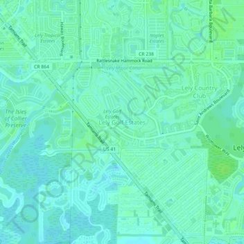
Name: Topografische Karte Lely Golf Estates, Höhe, Relief.
Durchschnittliche Höhe: 5 m
Minimale Höhe: 1 m
Maximale Höhe: 9 m
Andere topografische Karten
Klicken Sie auf eine Karte, um ihre Topografie, ihre Höhe und ihr Relief anzuzeigen.
Lely
United States > Florida > Collier County
Lely, Collier County, Florida, 34113, United States
Durchschnittliche Höhe: 5 m
Deep Lake
United States > Florida > Collier County
Deep Lake, Collier County, Florida, United States
Durchschnittliche Höhe: 5 m
Marco Island
United States > Florida > Collier County
Marco Island, Collier County, Florida, 34145, United States
Durchschnittliche Höhe: 2 m
Naples Park
United States > Florida > Collier County > Naples Park
Naples Park, Collier County, Florida, United States
Durchschnittliche Höhe: 6 m
North Naples
United States > Florida > Collier County
North Naples, Collier County, Florida, 35105, United States
Durchschnittliche Höhe: 7 m
Lely Country Club
United States > Florida > Collier County
Lely Country Club, Collier County, Florida, 34113, United States
Durchschnittliche Höhe: 5 m
The Moorings
United States > Florida > Collier County > Naples > The Moorings
The Moorings, Naples, Collier County, Florida, 34102:34103, United States
Durchschnittliche Höhe: 4 m
Naples
United States > Florida > Collier County
Naples, Collier County, Florida, United States
Durchschnittliche Höhe: 3 m