
Topografische Karte Birch Bay
Interaktive Karte
Klicken Sie auf die Karte, um die Höhe anzuzeigen.
Über diese Karte
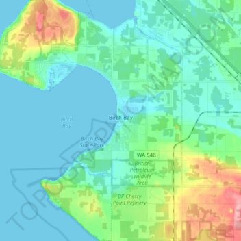
Name: Topografische Karte Birch Bay, Höhe, Relief.
Ort: Birch Bay, Whatcom County, Washington, United States (48.86935 -122.82263 48.96936 -122.70438)
Durchschnittliche Höhe: 21 m
Minimale Höhe: -2 m
Maximale Höhe: 104 m
Andere topografische Karten
Klicken Sie auf eine Karte, um ihre Topografie, ihre Höhe und ihr Relief anzuzeigen.
Point Roberts
United States > Washington > Whatcom County > Point Roberts
Point Roberts, Whatcom County, Washington, 98281, United States
Durchschnittliche Höhe: 9 m
Sudden Valley
United States > Washington > Whatcom County
Sudden Valley, Whatcom County, Washington, United States
Durchschnittliche Höhe: 239 m
Maple Falls
United States > Washington > Whatcom County
Maple Falls, Whatcom County, Washington, United States
Durchschnittliche Höhe: 442 m
Ferndale
United States > Washington > Whatcom County
Ferndale, Whatcom County, Washington, United States
Durchschnittliche Höhe: 29 m
Lynden
United States > Washington > Whatcom County
Lynden, Whatcom County, Washington, United States
Durchschnittliche Höhe: 26 m
Sumas
United States > Washington > Whatcom County
Sumas, Whatcom County, Washington, 98295, United States
Durchschnittliche Höhe: 15 m
Mount Baker
United States > Washington > Whatcom County
Mount Baker, Whatcom County, Washington, United States
Durchschnittliche Höhe: 2.699 m
Bellingham
United States > Washington > Whatcom County
Bellingham, Whatcom County, Washington, United States
Durchschnittliche Höhe: 89 m
Blaine
United States > Washington > Whatcom County
Blaine, Whatcom County, Washington, 98231, United States
Durchschnittliche Höhe: 23 m
Newhalem
United States > Washington > Whatcom County
Newhalem, Whatcom County, Washington, United States
Durchschnittliche Höhe: 492 m