
Spenden
Rüste dich für dein nächstes Abenteuer:
Als Amazon-Partner verdient diese Website an qualifizierten Käufen, ohne zusätzliche Kosten für Sie.
Topografische Karte Altamont Pass
Klicken Sie auf die Karte, um die Höhe anzuzeigen.
Spenden
Rüste dich für dein nächstes Abenteuer:
Als Amazon-Partner verdient diese Website an qualifizierten Käufen, ohne zusätzliche Kosten für Sie.
Altamont Pass
Altamont Pass, formerly Livermore Pass, is a low mountain pass in the Diablo Range of Northern California between Livermore in the Livermore Valley and Tracy in the San Joaquin Valley. The name is actually applied to two distinct but nearby crossings of the range. The lower of the two, at an elevation of 741 ft (226 m), carries two railroad rights-of-way (ROWs) and Altamont Pass Road, part of the old Lincoln Highway and the original alignment of US 50 before it was bypassed c. 1937. The bypass route travels over the higher summit, at 1,009 ft (308 m), and now carries Interstate 580, a major regional highway heavily congested by Central Valley suburbanization.
Spenden
Rüste dich für dein nächstes Abenteuer:
Als Amazon-Partner verdient diese Website an qualifizierten Käufen, ohne zusätzliche Kosten für Sie.
Über diese Karte
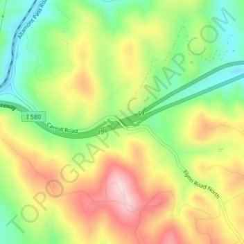
Name: Topografische Karte Altamont Pass, Höhe, Relief.
Ort: Altamont Pass, Alameda County, California, United States (37.71938 -121.66044 37.71948 -121.66034)
Durchschnittliche Höhe: 339 m
Minimale Höhe: 217 m
Maximale Höhe: 476 m
Spenden
Rüste dich für dein nächstes Abenteuer:
Als Amazon-Partner verdient diese Website an qualifizierten Käufen, ohne zusätzliche Kosten für Sie.
Andere topografische Karten
Klicken Sie auf eine Karte, um ihre Topografie, ihre Höhe und ihr Relief anzuzeigen.
Reinhardt-Redwood Regional Park
United States > California > Alameda County > Oakland
Durchschnittliche Höhe: 292 m
Horseshoe Lake
United States > California > Alameda County > Fremont > Eberly
Durchschnittliche Höhe: 23 m
Spenden
Rüste dich für dein nächstes Abenteuer:
Als Amazon-Partner verdient diese Website an qualifizierten Käufen, ohne zusätzliche Kosten für Sie.
Quarry Lakes Regional Park
United States > California > Alameda County > Fremont > Eberly
Durchschnittliche Höhe: 17 m
John F Kennedy Park
United States > California > Alameda County > Hayward
Durchschnittliche Höhe: 11 m
Oakland Casting Club pools
United States > California > Alameda County > Oakland
Durchschnittliche Höhe: 158 m
Spenden
Rüste dich für dein nächstes Abenteuer:
Als Amazon-Partner verdient diese Website an qualifizierten Käufen, ohne zusätzliche Kosten für Sie.
Dougherty Hills Open Space
United States > California > Alameda County > Dublin > Komandorski Village
Durchschnittliche Höhe: 120 m
Garin Regional Park
United States > California > Alameda County > Hayward
Durchschnittliche Höhe: 206 m
Lake Del Valle
United States > California > Alameda County
The dam is 230 feet (70 m) high and 880 feet (270 m) long. Its crest elevation is 773 feet (236 m). The dam contains 4,150,000 cubic yards (3,170,000 m3) of earth fill.
Durchschnittliche Höhe: 339 m
Spenden
Rüste dich für dein nächstes Abenteuer:
Als Amazon-Partner verdient diese Website an qualifizierten Käufen, ohne zusätzliche Kosten für Sie.