
Topografische Karte Forest Acres
Interaktive Karte
Klicken Sie auf die Karte, um die Höhe anzuzeigen.
Über diese Karte
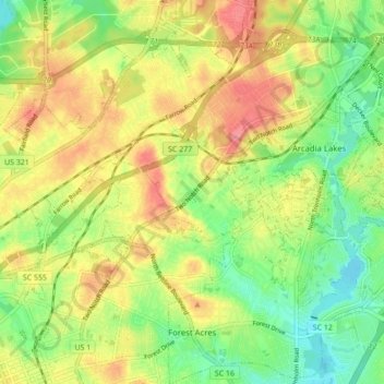
Name: Topografische Karte Forest Acres, Höhe, Relief.
Durchschnittliche Höhe: 85 m
Minimale Höhe: 47 m
Maximale Höhe: 126 m
Andere topografische Karten
Klicken Sie auf eine Karte, um ihre Topografie, ihre Höhe und ihr Relief anzuzeigen.
Richland County
United States > South Carolina > Richland County
Richland County, South Carolina, United States
Durchschnittliche Höhe: 84 m
Columbia
United States > South Carolina > Richland County
Columbia, Richland County, South Carolina, United States
Durchschnittliche Höhe: 89 m